Recently Established Chuyapi Urusayhua Conservation Area Protects Nearly 200,000 Acres of Forest, Over 1,500 Plant and Animal Species, and Essential Water Sources

Photo by Diego Perez R.

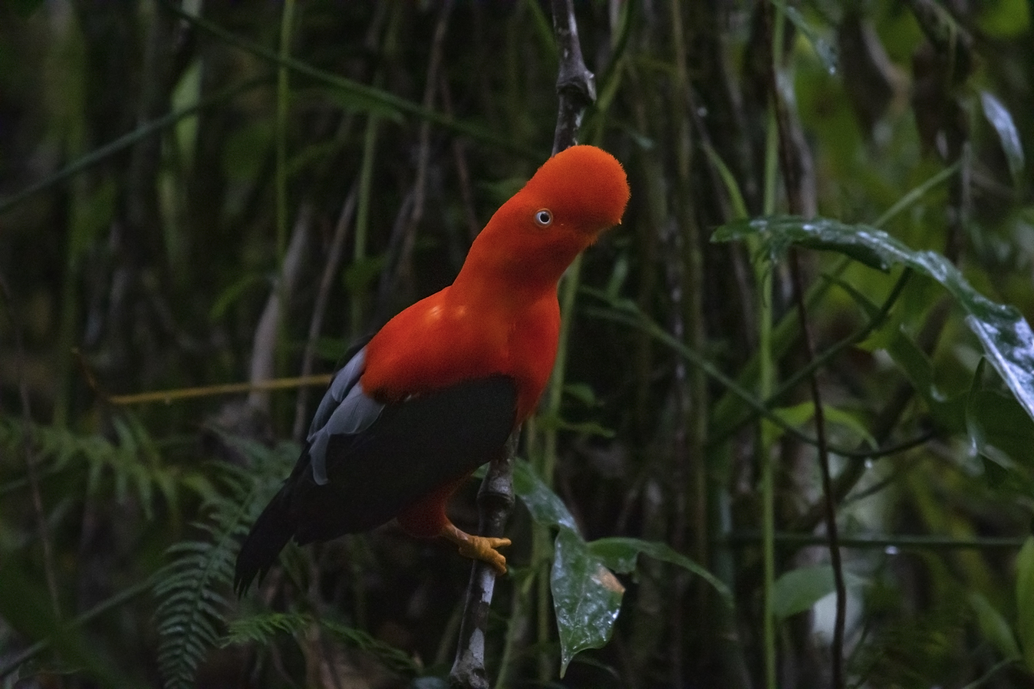
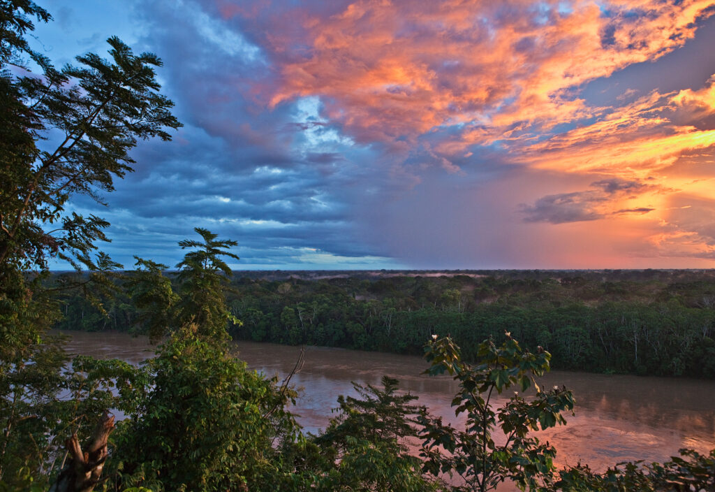
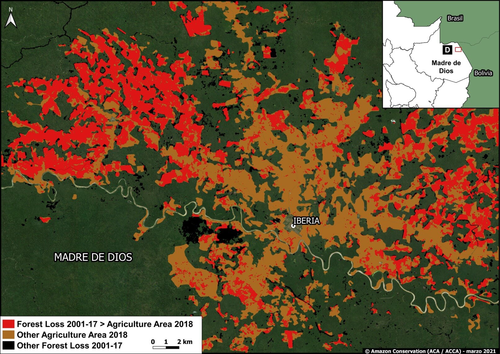
On March 24, 2021 the Chuyapi Urusayhua Conservation Area in the Peruvian Amazon was officially established, finalizing a long term effort that we have supported since 2008. This vast conservation area protects 197,000 acres (80,000 hectares) of forests — 93% Amazonian and 7% Andean — that are home to 936 registered species of plants and 619 species of animals such as pumas, jaguars, spectacled bears, quetzal, Peru’s national bird the cock of the rock, the blue-headed macaw, and many others. Furthermore, within the 1,555 species of plants and animals found in this area, 74 are endemic to Peru, and 22 of those exist only in Cusco. Additionally, located at the peaks of the Urusayhua mountain range are springs that are the main water sources for over 40,000 people who live in the nearby districts of Santa Ana and Echarati in Cusco. 


Ronald Catpo, Director of Conservation Areas at our sister organization Conservación Amazónica – ACCA, said the proposal for this area was drafted between 2007 and 2008, when the Regional Government of Cusco began to prioritize conservation for its most important ecosystems. “Since then,” he says, “and especially in the last four years, the effort (technical and logistical) has been concentrated to prepare the legal documents [for its establishment]. Initially it was called Urusayhua Regional Conservation Area, but in mid-2019 it officially changed to Chuyapi Urusayhua, at the request of the local population.”

Urusayhua, La Convencion Cusco Peru. Diego Perez R.

He emphasizes the ecological importance of the area, saying, “Within this conservation proposal of more than 80,000 hectares, there are five hydrographic basins (which are drainage basins of a stream): Cirialo, San Miguel, Cushireni, Vilcabamba and Chuyapi. The latter provides quality water to the population of Quillabamba, to 41,000 local people.”


The head of Peru’s Ministry of the Environment, Gabriel Quijandría, who spoke at our AmazonTEC conference last year, explained on social media how it will help create a mosaic of connected ecosystems, one of Amazon Conservation’s key strategies over the next decade. He says, “The area will allow connectivity between ecosystems of the jungle and high jungle such as Machu Picchu or Choquequirao and those typical of lower altitude tropical forests such as those located in Megantoni or Manu.”


Chuyapi Urusayhua Conservation Area By the Numbers:

  • This area is home to 936 registered species of plants and 619 registered species of animals.
    • Within this, there are 83 species of mammals, 412 of birds, 30 of amphibians, 22 of reptiles, 32 of beetles, 39 of butterflies and one species of scorpion.
    • Of the 1,555 species of plants and animals, there are 34 species of plants and 40 species of animals endemic to Peru, of which 22 only exist in Cusco
  • The area encompasses two ecoregions, that is, geographically defined areas with distinct ecosystems and species, 6 ecological floors, 12 ecological systems and the landscapes associated with the Urusayhua mountain.


This work has been made possible by the generous contributions of Gordon and Betty Moore Foundation, Andes Amazon Fund, and the support of many individuals, foundations, and corporations to our conservation work. 


Takeaways from “Technological Tools for Remote Monitoring of Protected Areas” Webinar

 Our sister organization Conservación Amazónica – ACCA recently organized and hosted the webinar “Technological Tools for Remote Monitoring of Protected Areas” in Spanish, for members and technical specialists from the Amarakaeri Communal Reserve.


This event featured esteemed presenters like Pedro Gamboa, Director of Peru’s National Service of Natural and Protected Areas (SERNANP); Fermin Chimatani, President of indigenous organization ANECAP; and Carlos Silva Cárdenas, the Director of the Research Management at the La Pontificia Catholic University of Peru (PUCP). Additionally, Beatriz Torres, Environmental Specialist of the Amazon at USAID Peru, presented opening remarks while Conservación Amazónica – ACCA Executive Director Maria Elena Gutierrez gave closing remarks.


Pedro Gamboa of SERNANP highlighted the importance of protecting conservation areas during the pandemic, as these forests provide countless ecosystem services that benefit local communities. He also highlighted the importance of technology for rangers doing foot patrols, adding that, “We have been working for a long time with the National Program of Forest Conservation, and specifically the management of deforestation  satellite imagery with Conservación Amazónica – ACCA.” 


Patrols gather information on threats in local forests, and then action is taken by local governments. “By having a government policy of the use of this technology, we would be able to identify not only threats but also opportunities.” Additionally, Pedro referenced their work restoring ecosystems affected by illegal mining in the Tambopata National Reserve, where technology has been vital. Drone photographs show the affected area, which is later reviewed to determine the access points to each of these places. Indigenous communal reserves, such as the Amanakaeri, are part of the surveillance in a co-management system, where the communities are directly involved. “The area where illegal gold mining takes place increases everyday. Thus, it is important to have this co-management. We hope that we’ll be able to replicate it in the other nine Indigenous Communal Reserves, so we can protect all of them.” Pedro added his thanks to the “many actors who have allowed us to consolidate an effective management system where we can conserve nature that help local populations, that then in turn help us conserve these areas.”


The next speaker was Fermin Chimatani, Fermin Chimatani, President of Peruvian indigenous organization ANECAP, the National Association of Contract Executors of the Administration. He highlighted their and SERNANP’s commitment to preserving forests saying, “We have been fulfilling this commitment [to protect the forests] hand-in-hand with the state…so that these communal reserves. as protected natural areas and ancestral territories, are at the service of local populations, indigenous communities, and the world, because of the importance of these spaces in terms of ecosystem services.”


Fermin also talked about how Amazonian communities in Peru are collectively organized in their indigenous territories and lands, in traditional ways that include diverse forms of political, economic, administrative representation. “As is the case with communal reserves, the forests are in the hands of indigenous peoples,” he says. “The work within the national system of protected natural areas is effectively done with equal conditions as partners that help guide the implementation and conservation policies. Thus, policies not only relate to conservation, but also to intercultural development.” There are ten communal reserves that help manage five million hectares of forests, counting the adjoining landscapes, in alliance with SERNANP, but Fermin says is not easy to be confident in an alliance with the state fighting for a common goal. Everything has been key and building trust. We have an agreement and responsibilities, obligations, and rights.” One of the tasks is to promote forest monitoring in a voluntary way that reinforces this, implementing strategies assisted by allied organizations who support with technological tools and training. “The important thing is the empowerment of the youth, of the young leaders.”


The final speaker was Carlos Silva Cárdenas, the Director of the Research Management at the La Pontificia Catholic University of Perú (PUCP), who spoke about the role of academia in technological innovation and protected areas. He began with an overview of how the pandemic has forced innovation as businesses and organizations try to advance during this unprecedented time. “The crisis caused by COVID 19 presents an opportunity that few feel prepared to take advantage of,” he said. “The implementation requirement differentiates innovation from other concepts, such as invention, because the innovation must be put into use or made available to others for their use.”


Carlos, who works in academia, emphasized how the first mission of a university is research and teaching. “Conditions must also be created so that startups or initiatives bring products to society, but always in a first stage, and then given autonomy.” Similarly, research groups, centers and institutes, should address research and innovation issues in an organized manner and in relation to the needs of society. He says, “Protected areas offer a good opportunity to facilitate the work of researchers through technology-based proposals that would accelerate the obtaining of and quality of results.” 


In conclusion, this webinar “Technological Tools for Remote Monitoring of Protected Areas”, was a well-rounded discussion that featured perspectives from various backgrounds. This event was organized by  Conservación Amazónica – ACCA, qAIRa and the Pontificia Universidad Católica del Perú-PUCP, with the collaboration of World Resources Institute, Digital Democracy, International Institute of Social and HIV Studies, and USAID Peru’s valuable support.


Protecting the Amazon – Today, Tomorrow, Forever

For two decades we’ve been protecting over 8.8 million acres of the greatest wild forest on Earth. The generosity and passion of our donors have provided cutting-edge technology tools to government and local authorities, empowered hundreds of indigenous communities to protect their ancestral lands, hosted over 500 pioneering scientific studies in the Amazon, and so much more. 

Several of our donors have taken their support one step further to add us to their wills and ensure a long-lasting impact in the Amazon that goes far beyond their lifetime.

To help anyone passionate about nature do the same, we are partnering with FreeWill,  an online tool that enables anyone to write a legal will – for absolutely no personal cost – and be able to easily set aside any portion of their estate for charity. This free tool is a result of our partnership with FreeWill, a social venture that since 2017 has empowered over 220,000 Americans to write their free wills.

This isn’t the type of tool Amazon Conservation usually partners with as an organization, but estate planning is a vital and easy way to support the people you love, as well as plan what you want your impact for nature to be in the long run. We share this free resource as a way for you to protect your family, get peace of mind of being prepared for the unexpected, and create an intentional plan for your future — just as the support of people like you has helped us plan for the future of the Amazon. Take Richard Hiemenz for example, and the massive impact he’s had with his planned gift that enabled us to create six conservation areas protecting over 700,000 acres of irreplaceable forests.

Nearly 70% of Americans don’t have an updated legal will, despite it being an essential task. FreeWill removes the expensive legal costs associated with writing a will, and takes 20 minutes or less to complete.  It removes the expensive legal fees associated with writing a will, making estate planning free and accessible for all. Simply put, this tool makes an often complicated task a bit easier.

The best part is that FreeWill makes it easy for you to cement your legacy with Amazon Conservation by creating an optional gift that supports the health and longevity of the beautiful Amazon. Legacy gifts from bequests and estate plannings support the continued protection and conservation of nature and cost nothing to you today. But they help us keep the Amazon standing for your children, grandchildren, and all generations to come. Your loved ones may also get benefits when you make a gift to charity through your will, such as getting reduced estate and income taxes, and potentially even eliminating capital gains taxes. We hope you will consider using this free resource and planning a gift to Amazon Conservation so that together we can keep the greatest rainforest on Earth thriving – forever.

Explore how to create a free will and leave a legacy gift for nature

If you have any questions about this resource, please contact info@amazonconservation.org. 


Using Comics to Inspire Children to Learn More About and Care for Amazonian Animals

This past World Wildlife Day, our sister organization Conservación Amazónica – ACEAA in Bolivia uniquely told the stories of Amazonian animals through their original comics series “Once Upon a Time in Your Forest”. 


The story stars a giant otter, an endangered species in the Amazon, who meets with forest friends around a campfire to tell a ‘scary story’ about an encounter with humans in the river. The series seeks to raise awareness, familiarize children living in Amazonian communities with their natural environment, and change the perception of wildlife by promoting the coexistence of humans and nature. This unique approach was met with a wave of positive feedback, from being featured in the prominent national Bolivian newspaper, Página Siete, to being invited to the a major news radio station Radio Expresión 106.6 FM, La Radio de los Periodistas.


Marcos Terán Valenzuela, Executive Director of Conservación Amazónica – ACEAA tells Página Siete how, when children living in communities in the Amazon were asked to draw their favorite animal, “they drew elephants, giraffes, lions … and not closer species such as jaguars or giant otters.” The objective of these short stories then became to inspire positive relationships and respect in children for animals living right in their local forest environment. 


“It is important to encourage childrens’ relationships with nature,” Marcos explains. “The educational curriculum should promote this with the support of the teachers, with the aim that future generations respect their environment by making conscious use of natural resources.” This is the second issue in the Once Upon a Time in Your Forest series. The first issue, starring a jaguar, another endangered species, was published last year and distributed to students in Amazonian communities of Pando and the north of La Paz. 


“The characters are animals from the Amazon that tell stories about their problems with humans,” Marcos elaborates. “They report encounters with humans where they get hurt or food is taken from them, so we want people to understand that humans are a threat to animals if their natural habitats aren’t respected. We also include the perspective of people who complain, for example, that giant otters eat their fish, when fish can be food for both humans and giant otters. The goal is to learn to coexist.” 


Though these comics address serious topics, the short stories in Once Upon a Time in Your Forest are characterized by silly, charismatic characters that young readers adore. Upcoming issues will feature other endangered or threatened species such as the giant anteater, tapir, agouti, and scarlet macaw.


Click here to read the comic in Spanish. English translation to come.


MAAP #134: Agriculture And Deforestation In The Peruvian Amazon

Peru’s first National Agricultural Area Map. Source: MIDAGRI.

For the first time, Peru has a detailed National Agricultural Area Map.

This unique map, produced with high-resolution satellite imagery, was published by the Peruvian Ministry of Agrarian Development (MIDAGRI) in January.*

This map reveals that the agricultural area at the national level is 11.6 million hectares, as of 2018.

Here, we analyze this new information in relation to annual forest loss data, generated by the Peruvian Environment Ministry (Geobosques).

The goal is to better understand the critical link between agriculture and deforestation in the Peruvian Amazon.

Specifically, we analyze the agricultural area of 2018 in relation to the preceding forest loss between 2001 and 2017.

Below are two main sections:

First, we present our Base Map that illustrates the major results.

Second, we show a series of zoomed images of select areas to illustrate key results in detail. These areas include major deforestation events related to oil palm, cacao, and other crops.


Base Map showing our major results. Data: MAAP, MIDAGRI, MINAM/Geobosques. Double click to enlarge.

Major Results

  • We found that 43% (4.9 million hectares) of Peru’s total agricultural area in 2018 was located in the Amazon basin.
  • Of these Amazonian agricultural areas, more than 1.1 million hectares (24%) came from forest lost between 2001 and 2017 (indicated in red on the Base Map).
  • Expressed another way, over half (56%) of the forest loss in the Peruvian Amazon between 2001 and 2017 corresponds to an agricultural area in 2018.
  • The Base Map also shows, in brown, the agricultural area that is not linked to recent forest loss. The vast majority is located outside the Amazon basin (western Peru).
  • Finally, the Base Map shows, in black, the recent forest loss not linked to agriculture. Much of this loss corresponds to gold mining (southeastern Peru), logging roads, and natural loss such as landslides.

Zooms of Key Areas

A. United Cacao (Loreto)

Image A shows the large-scale deforestation associated with the company United Cacao between 2013 and 2016, in the Loreto region  (MAAP # 128). The clearing, as the name indicates, was for the installation of Peru’s first and only industrial-style cacao plantation. In total, the deforestation for the plantation reached 2,380 hectares.

Zoom A. United Cacao (Loreto region). Data: MAAP, MIDAGRI, MINAM/Geobosques.

B. Oil Palm (Shanusi, Loreto)

Image B shows the large-scale deforestation of more than 16,800 hectares associated with oil palm plantations between 2006 and 2015, along the border of the Loreto and San Martin regions (MAAP #116). Of this total, the deforestation of 6,975 hectares was linked to two plantations managed by the company Grupo Palmas company. The remainder occurred in the private areas surrounding the company’s plantations.

Zoom B. Oil palm deforestation around Shanusi (Loreto region). Data: MAAP, MIDAGRI, MINAM/Geobosques.

C. Oil Palm (Ucayali)

Image C shows the large-scale deforestation of more than 12,000 hectares for two oil palm plantations between 2011 and 2015, in the Ucayali region (MAAP #41).

Zoom C. Oil palm deforestation (Ucayali region). Data: MAAP, MIDAGRI, MINAM/Geobosques.

D. Iberia (Madre de Dios)

Image D shows the expanding agriculture-related deforestation around the town of Iberia, near the border with Brazil and Bolivia (MAAP #75). The major cause, according to local sources, is the increase in corn, papaya, and cacao plantations. We have documented the deforestation of more than 3,000 hectares in this area since 2014.

Zoom D. Agriculture related deforestation around Iberia (Madre de Dios region). Data: MAAP, MIDAGRI, MINAM/Geobosques.

E. Zona Minera (Madre de Dios)

Finally, Image E shows deforestation in the gold mining hotspot known as La Pampa, in the Madre de Dios region. The non-agricultural deforestation in the center is the major illegal gold mining front. Around that area, and along the Interoceanic Highway, there is extensive agriculture-related deforestation.

Zoom E. Mining and agriculture deforestation in southern Peru (Madre de Dios region). Data: MAAP, MIDAGRI, MINAM/Geobosques.

*Notes and Methodology

According to MIDAGRI, the National Agricultural Area Map was “generated based on satellite images from RapidEye and later updated with satellite images from Sentinel-2 and the Google Earth platform, which allowed the mapping and precise measurement of the agricultural surface throughout the national territory.”

The data include “agricultural land with cultivation and without cultivation.” We assume that these data include cattle pasture.

The identification and quantification of deforested areas (2001-2017) that correspond to agricultural area in 2018 results from the analysis carried out in GIS by the superposition of both geospatial layers (MINAM and MIDAGRI).

Amazonian agricultural areas that came from forest lost between 2001 and 2017 = 1,185,722 hectares (indicated in red on the Base Map).

Acknowledgments

We thank E. Ortiz (AAF), S. Novoa (ACCA) and G. Palacios for their helpful comments on this report.

Citation

Vale Costa H, Finer M (2021) Agriculture and Deforestation in the Peruvian Amazon. MAAP: 134.

Establishing an Action Plan With Indigenous Partners to Conserve Three Areas in the Peruvian Amazon

In a meeting with representatives from the Amarakaeri Communal Reserve, an indigenous community in Peru, and the Puerto Azul Mberowe Native Community, we established a joint action plan to protect three key areas in the Peruvian Amazon: the Madre de Dios Territorial Reserve, the Amarakaeri Communal Reserve, and our Los Amigos Conservation Concession.


During the meeting Juan Loja, the Director of our sister organization’s (Conservación Amazónica – ACCA) Madre de Dios office, and the president of Amarakaeri’s leadership group, Walter Quertehuari, agreed there is a mutual need to join forces to reduce illegal activities, such as the illegal logging that threatens the three territories. They highlighted the importance of these efforts to strengthen the technology-based deforestation monitoring efforts in the region and promote sustainable economic activities in the ten indigenous communities that are partners of the reserve.


Asvín Flórez, head of the Amarakaeri Communal Reserve, noted that the collective work between the community, co-management, and Conservación Amazónica – ACCA will be important to continue strengthening livelihood of communities through conservation. Venancio Corisepa, another member of the community, said one of the first actions would be to establish boundaries between their community and the Los Amigos Concession. In addition, they proposed the continuation of strengthening and supporting community forest rangers that guard the forests.


Juan Loja also underlined the importance of consolidating this joint venture between three organizations, since the collaborative work with Puerto Azul will help us protect the proposed Madre de Dios Territorial Reserve where uncontacted indigenous peoples (referred to by the acronym PIACI in Spanish) reside.


Satellite Images of “Rivers of Gold” Raise Awareness of Major Deforestation in the Amazon

Image by International Space Station

An image provided by the International Space Station has been circulating around the internet showing an aerial view of cascading ‘rivers of gold’ in the Peruvian Amazon. These fascinating ‘rivers’ are in fact destructive and toxic pits that form as a result of illegal gold mining activities. Though these pits are a common sight for our GIS team, many media companies and the subsequent public were shocked by this unusual sight, inspiring a wave of recent news articles from around the world.


With the increase in illegal gold mining in the Peruvian Amazon come deforestation, mercury poisoning to community water sources, and social conflicts including prostitution and forced labor. As the demand for gold continues to increase, this illegal practice has expanded farther and farther into sensitive Amazonian ecosystems.


However, we’re keeping an eye on these activities from above, and then use this information to aid authorities working on the ground down below. Satellite imagery company Planet published an article about how we were using data from satellite imagery to crack down on illegal gold mining. “The vastness of the Amazon can be a major challenge to its conservation, but technology, especially satellites, have emerged as an extremely powerful tool,” says Dr. Matt Finer, our Senior Research Specialist and Director of their Monitoring of the Andean Amazon Project (MAAP).  “With the latest generation of satellites and related algorithms, we have been able to go from annual to more real-time monitoring. And it is this real-timeness that makes all the difference in linking this technology with effective policy action on the ground to reduce and avoid deforestation.”  


MAAP aims to document the most urgent deforestation cases in near real-time and identify the direct causes of deforestation in the Andean Amazon. In doing so, MAAP is able to better understand larger-scale deforestation patterns, hotspots, and drivers. With this information, MAAP is able to improve policy and conservation action based on this cutting-edge technical information. 


“Publishing this imagery is a new way to show the problem”, Matt Finer told Spanish news giant Agencia Efe. “It allows more people on a global scale to see it.”


“Paco” Fish Farms Advance Aquaculture in the Peruvian Amazon

Photo of paco fish farm Amazon ConservationThis February saw the installment of a fish farm that will help generate sustainable livelihoods in the Peruvian Amazon and act as an important food source for local people. Located in the small district of Inambari, Madre de Dios near major conservation areas like the extensive National Tambopata Reserve, this initiative contributes to the development of aquaculture activities by offering low-cost fish feed for the different stages of cultivation of the Piaractus brachypomus fish – commonly known as “Paco” -, as well as other omnivorous Amazonian species. Paco are an important food source for local communities as it has a high protein content. The feed has been put through an ‘extrusion’ method, which means that it has gone through a cooking process that uses high temperatures and pressure for a short period of time.

The idea for this initiative began with a local association of aquaculturists (called Asociación de Acuicultores de Primavera Alta y Primavera Baja) when they saw the need to lower the costs of running sustainable fish farms to make them better alternatives to other forms of livelihoods that may destroy the rainforest. Thanks to financing by Amazon Conservation and the Peruvian government’s National Program for Innovation in Fisheries and Agriculture (PNIPA), this association is now able to feed their paco fish farms at a lower cost, also showing their neighboring communities that conservation and sustainable living can be done.

This is one of the many ways our Alliance is promoting sustainable livelihoods and food security for people who call the Amazon home. 


New Biodiversity Monitoring Projects at Los Amigos Conservation Hub

Camera trap photo of a white lipped peccary by Amazon ConservationResearchers Dr. Andy Whitworth and Dr. Henry Pollock from Osa Conservation began a new research project at our Los Amigos Conservation Hub to assess how many white-lipped peccaries are present in the world’s first conservation concession.  This species has a vulnerable status with the IUCN red list and was recorded to have almost disappeared in this region of Peru for 12 years until we began to see it again at Los Amigos with prior camera trap photography efforts.

The team has already installed 30 camera traps in a grid covering 3.7 square miles (6 square km) to monitor this type of peccary and try to understand how healthy the local population is. This continued effort to learn more about this species will help guide our conservation efforts to keep it from moving closer to extinction.

Not only are we tracking peccaries at Los Amigos, but during the next few months researchers led by our co-founder Dr. Adrian Forsyth,  Dr. Alejandro Lopera-Toro, and scientists from the local University of San Antonio Abad Del Cuzco will be conducting studies on the diversity of beetles in the different types of forests around this Conservation Hub. They will also conduct ecological and behavioral studies around beetle species, helping improve our knowledge of these important supporters of the rainforest’s ecosystems.

We are looking forward to the new discoveries of our researcher friends!


MAAP #133: Deforestation Continues In National Parks Of Colombian Amazon

Base Map. Deforestation 2020-21 in the National Parks of the Colombian Amazon. Data: MAAP.

As we have indicated in previous reports (MAAP #120), there is an “arc of deforestation” in the northwest Colombian Amazon, impacting numerous protected areas and indigenous reserves.

Here, we emphasize that this deforestation currently impacts four National Parks: Tinigua, Macarena, Chiribiquete and La Paya.

In the Base Map, the red circles indicate the areas most impacted by recent deforestation within these parks.

The letters (A-D) indicate the location of the high-resolution satellite images (Planet) below.

While Tinigua and Macarena continue as the most impacted National Parks, below we focus on the new deforestation fronts in Chiribiquete and La Paya.

Specifically, we show the most recent and urgent deforestation, since September 2020 to the present (February 2021).


Chiribiquete National Park

Chiribiquete National Natural Park lost more than 1,000 hectares (2,500 acres) in the last six months, in six different areas of the park (see Base Map above). Much of this deforestation appears to be associated with the conversion of primary forest to illegal cattle pasture. The following satellite images show deforestation in three of these areas (A-C) between September 2020 (left panel) and February 2021 (right panel). *It is important to note that immediately prior to this publication authorities carried out a major intervention to crack down on the illegal activity within the park (see news here).

Image A. Deforestation in Chiribiquete National Park, western sector 1. Reference coordinate: 1.05497 ° N, 74.26465 ° W. Data: Planet, MAAP.
Image B. Deforestation in Chiribiquete National Park, western sector 2. Reference coordinate: 1.57990 ° N, 73.78689 ° W. Data: Planet, MAAP.
Image C. Deforestation in Chiribiquete National Park, northern sector 1. Reference coordinate: 2.00975, -73.45541. Data: Planet, MAAP.


La Paya National Park

La Paya National Park lost more than 150 hectares (370 acres) in the last six months, in the northwest sector of the park (see Base Map above).
.
The following image shows an example of deforestation in this sector of the park between September 2020 (left panel) and January 2021 (right panel).

Image D. Deforestation in La Paya National Park, northern sector. Reference coordinate: 0.39677 ° N, 75.48505 ° W. Data: Planet, MAAP.

Fire Season

In addition, the fire season has started in the Colombian Amazon. Interestingly, now (February to March) is typically Colombia’s peak deforestation and fire season, in contrast with Brazil, Bolivia, and Peru, whose seasons peak between June and October.

The following very high-resolution images (Skyat) reveal the burning of recently deforested areas within Chiribiquete National Park.

Fire inside Chiribuete National Park (February 11, 2021) burning recently deforested areas. Data: Planet (Skysat).
Zoom of fire inside Chiribuete National Park (February 11, 2021) burning recently deforested areas. Data: Planet (Skysat).

Acknowledgmens

We thank R. Botero (FCDS) and G. Palacios for their helpful comments on this report.

Citation

Finer M, Mamani N (2021) Deforestation Continues in National Parks of Colombian Amazon. MAAP: 133.