Drones Empower Community Members to Take Part in Reporting and Stopping Crimes Against Their Forests


southwest amazon drone center
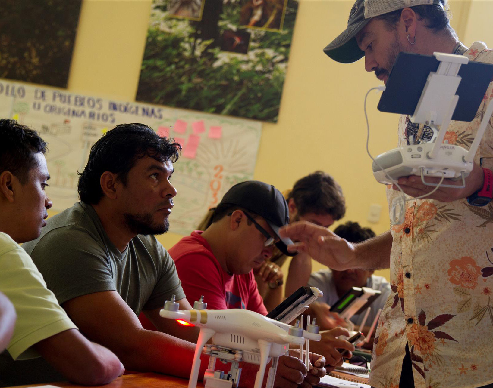
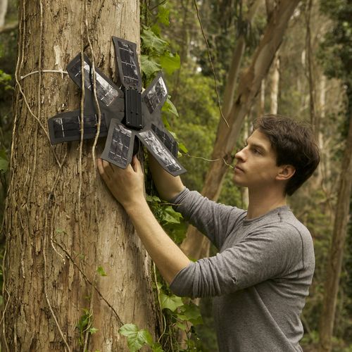
Our Southwest Amazon Drone Center is training local landowners, forest users, indigenous communities, students, and government officials to use cutting-edge satellite, smartphone, and drone technology to monitor and stop deforestation. We provide local people with the technology, knowledge, legal support, and connections they need to safely and effectively take action.

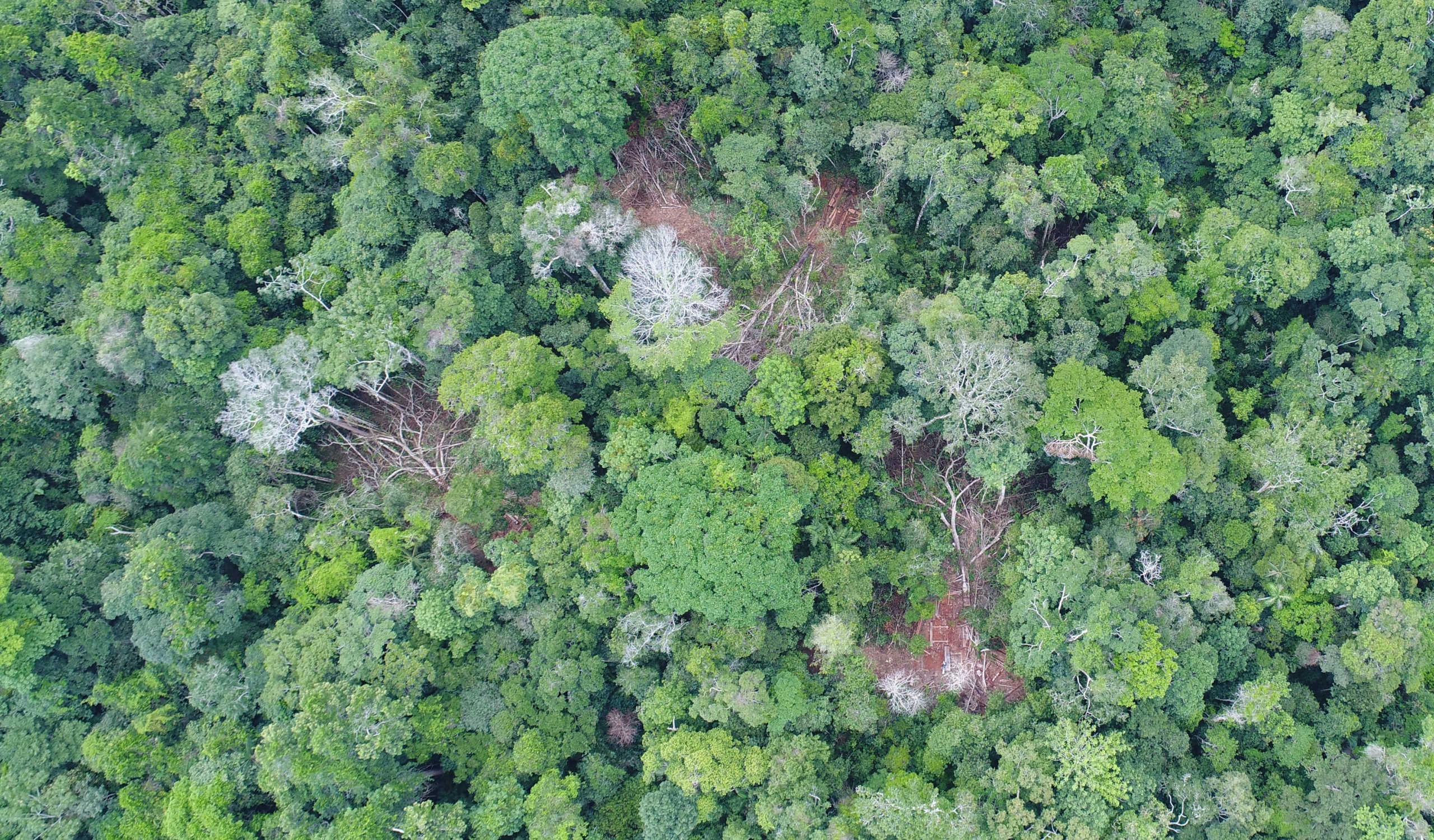
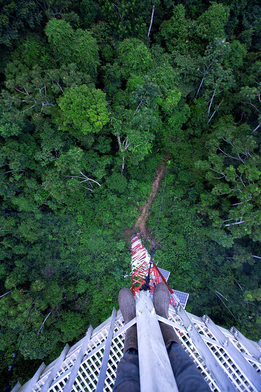
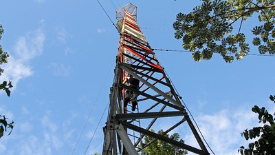
In 2019, we trained and certified 89 individuals in using drones and smartphone apps to detect illegal activities in remote areas of their forests, and report them using drone imagery as legally-admissible evidence for law enforcement to be able to take action and prosecute offenders.

Marcelina, Drone pilot
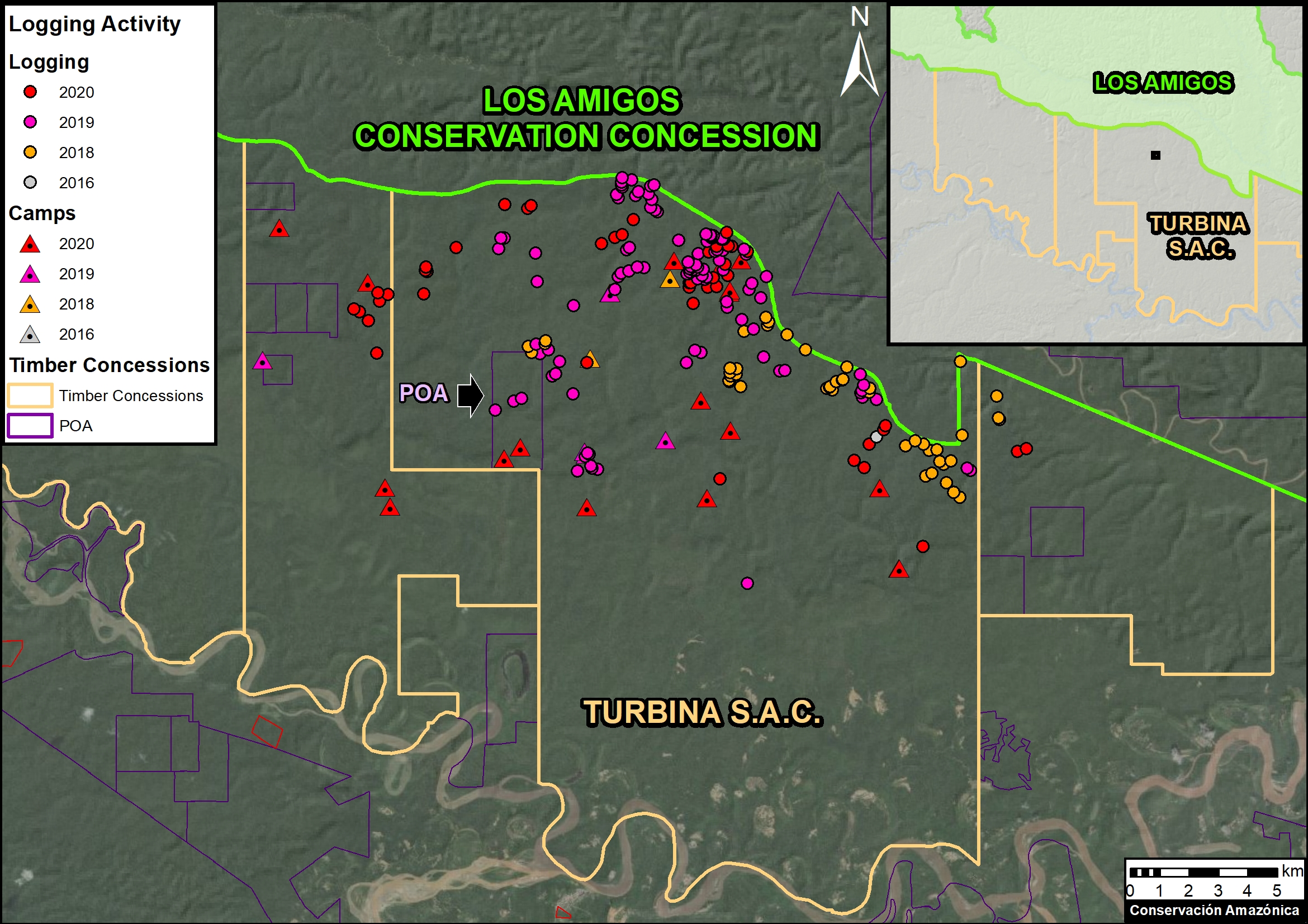
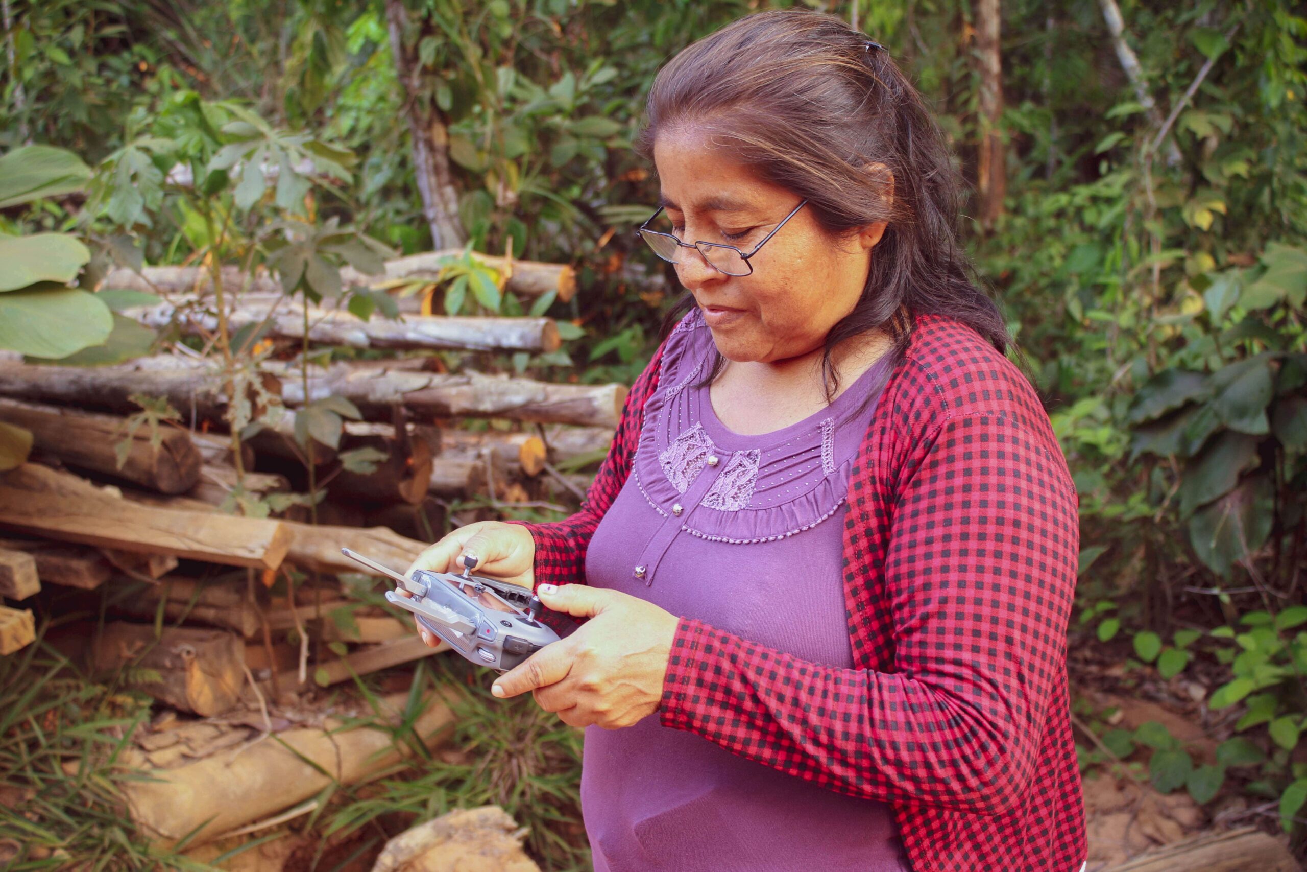
Sixteen of the new users were women, and their numbers continue to increase as we focus on their inclusion in this type of training. We also trained and helped the local association of forest users known as ACOMAT in carrying out 26 patrols using their newly-acquired technological capabilities (drones, satellite imagery and/or mobile applications). These patrols detected 16 incidents of illegal activity in 9 areas, and a total of 5 criminal complaints were filed with the local government of the Madre de Dios region of Peru, which are currently being addressed by the authorities. We were also able to hold six specialized trainings for volunteer community park guards (called Forest Custodians), who combine our technology with their traditional foot patrols inside protected areas.

southwest amazon drone center photo of logging
Drone footage of illegal logging in the area

Beyond directly providing the actual drone and smartphone technology to these communities and individuals, we also provide continued training, certifications, and drone maintenance workshops to support their long-term fight to keep forests protected. This approach has been become so successful that it is known as the “ACOMAT Model” in Peru, and, due to its high demand, we are beginning to replicate it in other areas of Peru in addition to making it available to other countries in the Amazon.

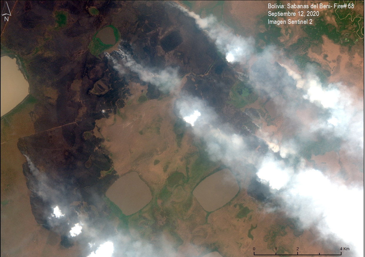
All in all, this work marks a key first step for communities to effectively engage the government and compel them to take action by providing clear evidence of illegal activities in a timely (meaning in real time – while the illegal activity is still going on), cost effective, high-tech way.

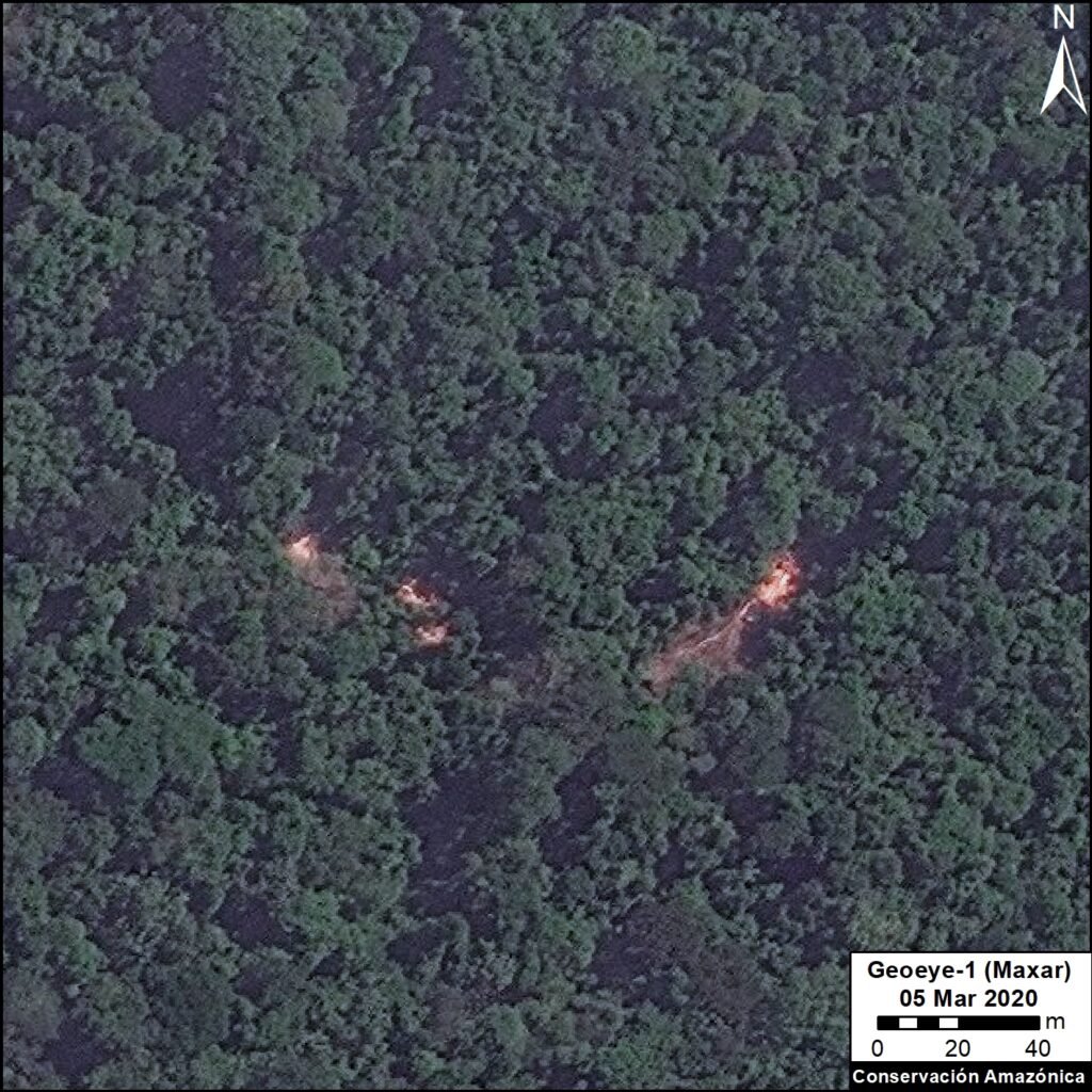
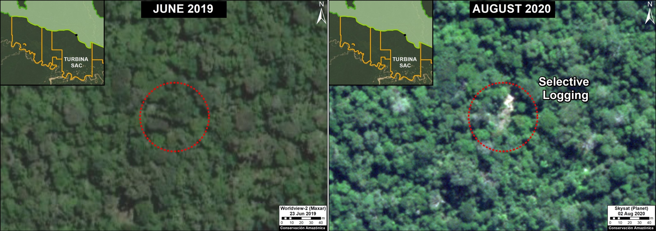
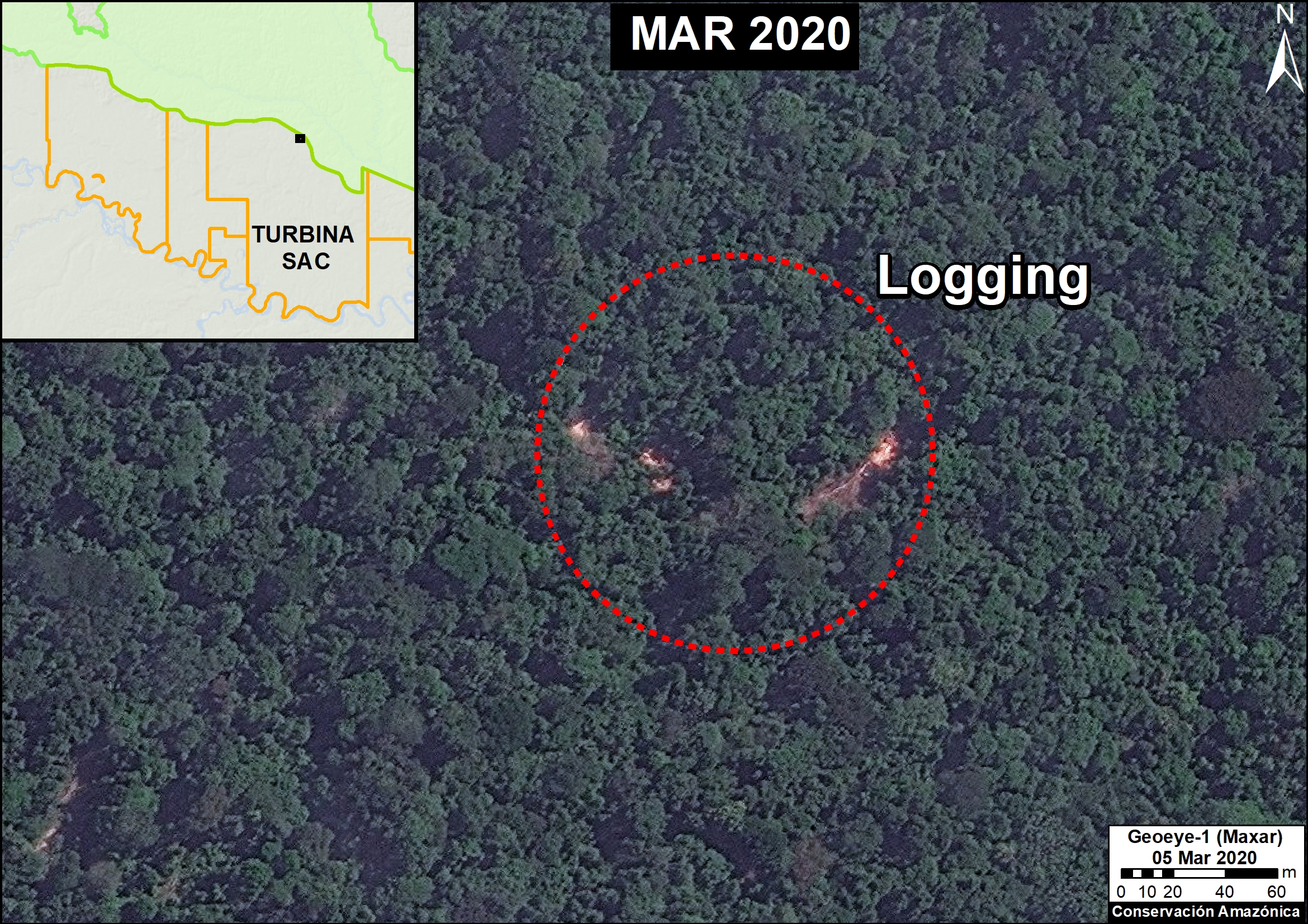
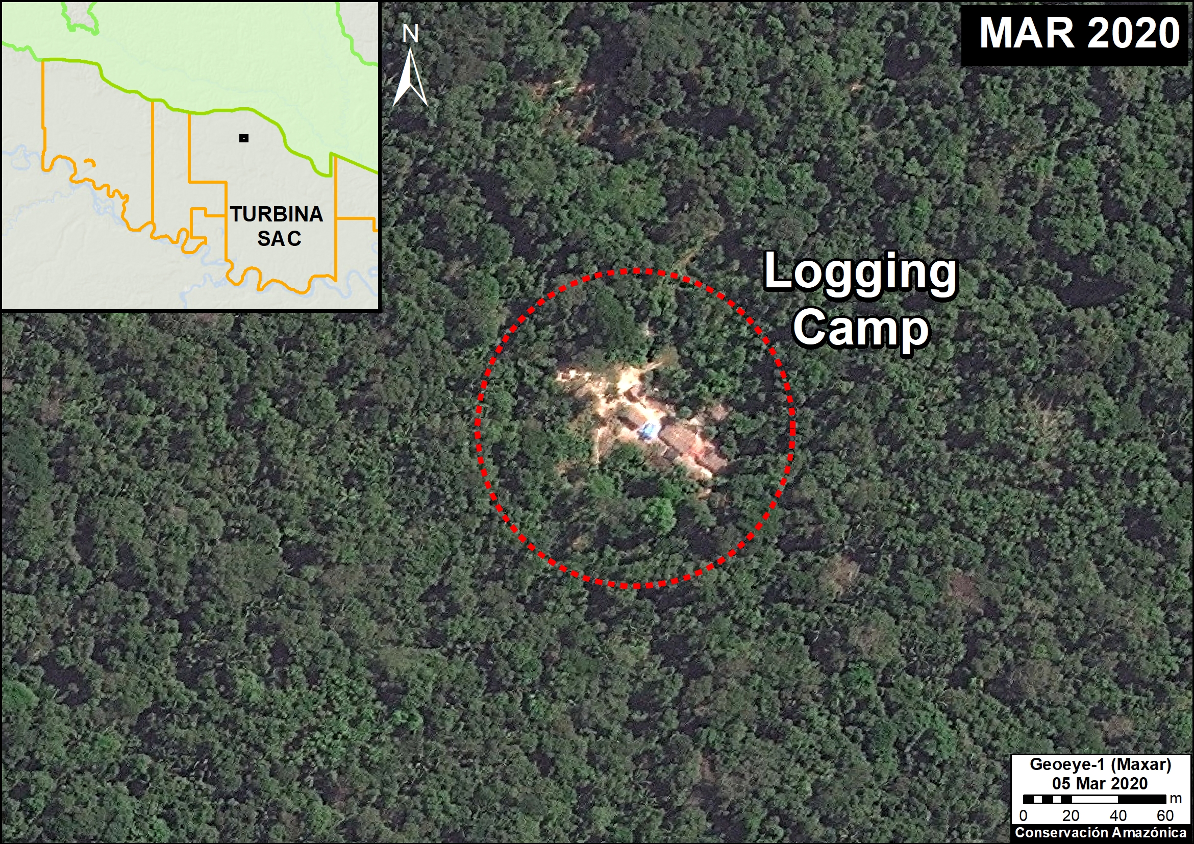
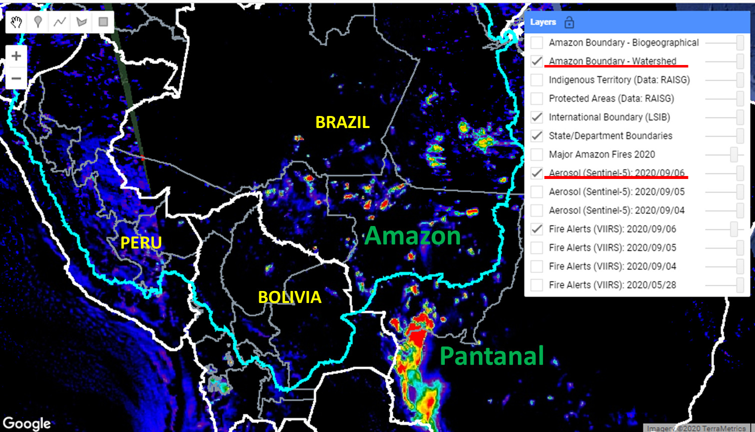
Click here to read how ACOMAT members were recently able to detect illegal logging via drones.

Special thanks to The Sheldon and Audrey Katz Foundation, the members of the Cloud Appreciation Society, the
Norwegian Agency for Development Cooperation, and all individuals and organizations whose generous support made this project possible.

Understanding The Birds Of Tahuamanu

Woodcreeper birdOur bird survey at the Tahuamanu Biological Station is determining the ornithological diversity that the area protects, as well as establishes a baseline for their conservation and the development of birdwatching activities for ecotourists.

This project was carried out by creating two field camps for the researchers to cover all of the major habitat types. The first camp was based at the Tahuamanu station itself, from which the tours to the nearby Tahuamanu River area were made, enabling researchers to visit the lowland Amazonian forests and bamboo forests. The second camp was located outside the station, in order to understand the abundance and diversity of birds in the surrounding areas including unique riverbanks, grasslands and other lowland forests.

Researchers at both camps used a “Play Back” method (a best practice proposed in the research of Villareal et al. 2004), which consists of using recordings of birds at a moderate volume to draw them Comparison Graphnear, combined with a very light weight 40-foot net to capture the ones that fly by. Once captured, the birds were safely identified and photographed and released back into their habitat. We used world-class specialized field biology guides to ensure the proper identification and classification of these birds.

In total, we identified 267 species of birds belonging to 179 genus and 49 taxonomy families. The best represented species were the flycatcher family (Tyrannidae) with 28 species, followed by Ovenbirds (Furnaridae) and Antbirds (Thamnophilidae) with 25 species each (see the figure below for an overall distribution of the most commonly-found species).

Rufous-fronted antthrushTwelve of these species were listed under different categories of threat on the IUCN Red List, such as the endangered White-bellied parrot (Pionites leucogaster) and the Channel-billed Toucan (Ramphastos vitellinus).

Additionally, this species of Rufous-fronted antthrush is known in just two places in Bolivia. Living in riverbanks, it is difficult to observe as it’s very elusive. We were able to capture and photograph this bird as part of this project, which shows the importance of conservation areas and research stations like Tahuamanu in keeping threatened species like this one thriving.

Lastly, we also were able to identify four new species that were never recorded before in this area! These 267 Total species recorded, 12 threatened species identified, 4 new species found graphicspecies were the White-throated King bird (Tyrannus albogularis), Slender-billed Xenops (Xenops tenuirostris), Elegant Woodcreeper (Xiphorhynchus elegans), and the Ocellated Woodcreeper (Xiphorhynchus ocellatus). These findings add another layer of value to demonstrate to local authorities and communities the importance of protecting this area: to avoid the extinction of these species, let scientists know where they can go to conduct avian research, and where ecotourists can go to observe these species.

Special thanks to The Sheldon and Audrey Katz Foundation for their generous support that makes this project possible.

MAAP: Fires In The Bolivian Amazon 2020

Base Map. Major fires in the Bolivian Amazon during 2020. Data: MAAP/ACEAA.

We have detected 120 major fires this year in the Bolivian Amazon, as of the first of October (see Base Map).*

The majority of these fires (54%) occurred in savannas, located in the department of Beni.

Another 38% of the major fires were located in forests, mostly in the dry forests of the Chiquitano.

We emphasize that 25% of the major fires were located in Protected Areas (see below).


*The data, updated through October 1, is based on our novel real-time Amazon Fires Monitoring app, which is based on the detection of elevated aerosol emissions (by the European Space Agency’s Sentinel-5 satellite) that indicate the burning of large amounts of biomass (defined here as a “major fire”).


Major Fires in Protected Areas of the Bolivian Amazon in 2020. Data: MAAP/ACEAA.

Major Fires in Protected Areas

The most impacted Protected Areas are Noel Kempff Mercado National Park (21,000 acres burned), and Copaibo Municipal Protected Area (99,000 acres burned hectares).

Other impacted Protected Areas impacted include Iténez National Park, Keneth Lee Reserve and Pampas del Río Yacuma Integrated Management Natural Area.


Satellite Images of the Major Fires in the Bolivian Amazon

We present a series of high-resolution satellite images of the major fires in the Bolivian Amazon.

Image 1 shows a major fire in the extreme northwest of Noel Kempff Mercado National Park in September. Note that the fires are burning in the transition between Amazon forest and savanna.

Image 1. Major Fire #61 (Sept 8, 2020). Data: Planet.

Image 2 shows a major fire in Copaibo Municipal Protected Area in September. Note that it is located in the transition zone of the moist Amazon forest and Chiquitano dry forest.

Image 2. Major Fire #65 (September 7, 2020). Data: Planet.

Image 3 shows another major fire in Copaibo Municipal Protected Area, also in the transition zone of the Amazon forest and the Chiquitano dry forest.

Image 3. Major Fire #51 (September 4, 2020). Data: Planet.

Image 4 shows a major fire in the savannas of Beni.

Image 4. Major Fire #68 (September 12, 2020). Data: Planet.


Citation

Finer M, Ariñez A (2020) Fires in the Bolivian Amazon 2020. MAAP.

MAAP#125: Detecting Illegal Logging With Very High Resolution Satellites

Very high resolution satellite image showing illegal logging in the southern Peruvian Amazon. Data: Maxar. Analysis: MAAP/ACCA.

Illegal logging in the Peruvian Amazon is mainly selective and, until now, difficult to detect through satellite information.

In this report, we present the enormous potential of very high resolution satellite imagery (<70 cm) to identify illegal logging.

The leading entities that offer this type of data are Planet (Skysat) and Maxar (Worldview).

We emphasize that this technique has the potential to detect the illegal activity in real time, when preventive action is still possible.

This is an important advance because when an intervention normally occurs, such as detaining a boat or truck with illegal timber, the damage is done.

Below, we show a specific case of using very high resolution satellite imagery to detect and confirm probable illegal logging in the southern Peruvian Amazon (Madre de Dios region).


Base Map. Illegal logging activities in the Turbina SAC forestry concession. The size of the points is for reference only. Data: MAAP/Amazon Conservation.

Case: Turbina SAC

The Base Map below shows the intensity of probable illegal logging activity* in the Turbina SAC forestry concession, from 2016 to the present. Specifically, it shows the exact points of illegal logging events (felled trees) and logging camps, as identified through our analysis of very high-resolution satellite images. Note that this forestry concession is adjacent to the Los Amigos Conservation Concession, an important long-term (20 years) biodiversity conservation area.


Very High Resolution Satellite Imagery

Below, we show a series of very high-resolution satellite images, courtesy of the innovative satellite companies Planet and Maxar.

The first image shows the identification of probable illegal logging between June 2019 (left panel) and August 2020 (right panel). The red circle indicates the exact area (canopy) of the illegally logged tree.

The identification of illegal logging between June 2019 (left panel) and August 2020 (right panel). Click to enlarge. Data: Maxar, Planet, MAAP.

The following image shows the identification of illegal logging in March 2020. The red circle indicates the exact area of the illegally logged trees.

Identification of illegal logging. Data: Maxar, MAAP.

The following image shows the identification of a logging camp in March 2o20. The red circle indicates the area of the camp.

Satellite image of an illegal logging camp. Data: Maxar, MAAP.

*Statement on Legality

We determined that this logging activity is illegal from a detailed analysis of official information from the Peruvian Government (specifically, the Peruvian Forestry Service, SERFOR, and forestry oversight agency, OSINFOR). This information indicates that, although the concession is in force (Vigente), its status is classified as Inactive (Inactiva). In addition, 2013 was the last year that this concession had an approved logging plan (Plan Operativo de Aprovechamiento, or POA), and it was for a different sector of the concession from the newly detected logging activity.

To confirm our assumption of illegal activity, we requested the technical opinion from the corresponding regional forestry and wildlife authority, however, as of the date of publication of this report, we have not yet received a response.

Thus, with the information we had at the time of publication, we concluded the logging was illegal as it was not conducted within a current management plan.

Methodology

We carried out the analysis in two main steps:

The first step was the visual interpretation and digitization of new logging events and associated logging camps within the Turbina forestry concession. This analysis was based on the evaluation of submetric images obtained from the satellite companies Planet and Maxar, for the period 2019-20. It is worth noting that for Planet, we had the new ability to “task” new images for a specific area, rather than waiting for an image to appear by other means. Logging in the Peruvian Amazon is usually highly selective for high-value species, thus its detection requires a comparative analysis of images (before and after), in such a way that the trees cut during the study period (2019-20 in this case) can be identified.

The second step focused on an analysis of the legality of the identified logging events. The locations of the logged trees and camps were cross-referenced with spatial information on the state and status of forestry concessions provided by the GeoSERFOR (SERFOR) portal, as well as the areas delimited in the annual operational plans of the concessions, verified by OSINFOR and distributed through the SISFOR portal (WMS). We considered both spatial and temporal aspects to the forestry concession data.

Citation

Novoa S, Villa L, Finer M (2020) Detecting Illegal Logging with Very High Resolution Satellites. MAAP: 125.


Acknowledgments

We thank A. Felix (USAID Prevent), M.E. Gutierrez (ACCA), and G. Palacios for their helpful comments on this report.

This report was conducted with technical assistance from USAID, via the Prevent project. Prevent is an initiative that, over the next 5 years, will work with the Government of Peru, civil society, and the private sector to prevent and combat environmental crimes in Loreto, Ucayali and Madre de Dios, in order to conserve the Peruvian Amazon.

This publication is made possible with the support of the American people through USAID. Its content is the sole responsibility of the authors and does not necessarily reflect the views of USAID or the US government.


Improving The Computer Model For Identifying Brazil Nut Trees

Amazon Conservation had successfully developed a computer-based tool that identifies Brazil nut trees using high-resolution satellite imagery and drones in pilot areas covering 300,000 hectares (see blog post here). This year, we adapted our methodology and converted our model into a Google Earth Engine development environment to enable it to be used in a different computer language with significant technical benefits – including making it more user-friendly and accessible by others. This improvement made it possible for this tool to be applied to other areas of the Bolivian Amazon, including the municipalities of Porvenir, Puerto Rico, and Santa Rosa del Abuná.

Satellite models
Computer models, drones, and satellites are helping us identify productive trees in dense forests, which can grow sustainable economies locally and regionally. These might be seem like just dots on a computer screen, but they hold the potential to make forest-based economies viable in a large scale and increase the demand for environmental protection.

It also enabled us to streamline the calculation processes, significantly reducing the computation time involved in the first version of our model and making us more agile in our analysis. The improvement of our Brazil nut tree identification tool enabled us to move forward while pandemic restrictions are in force and staff and communities cannot go into the field. Although we had planned to expand this effort initially by employing extensive field work to fly drones to gather this data, we were able to make this technological advancement first, which will make future field validation an easier process.

Brazil nut tree This advancement provides us with a sufficient base for determining the Brazil nut production potential of the 34.5 million acres of productive forests that we are focused on and to develop complementary algorithms to identify other economically and ecologically viable palm species like açaí, Palma Real, and Majo.

We are excited about the potential of this breakthrough and continuing to generate more innovative tools based on this type of technology, as it is helping us provide solutions to improve food security, decrease deforestation, and strengthen the forest-based economy that these communities are striving for.

Special thanks to The Sheldon and Audrey Katz Foundation for their generous support that makes this project possible.

Protecting River Turtles From Potential Extinction

Traditionally, local communities surrounding Tahuamanu have consumed the eggs of Yellow-spotted river turtles (Podocnemis unifilis, commonly known as peta in Spanish) as an important protein source for their diet.

Photo of Yellow-spotted river turtle (Podocnemis unifilis)However, with village expansion accelerating demand for these eggs as well as increasing river traffic damaging local basins, these turtles face increased pressures from loss of habitat and overharvesting. Plus, with the boom in globalization, the use of peta eggs has developed from a local tradition into a full-fledged illegal trade, as outsiders loot eggs on the beaches of local rivers to sell in large urban centers throughout Bolivia and across the border in Brazil and Peru. Because of these factors, the peta is now listed by the International Union for Conservation of Nature’s Red List of Threatened Species (IUCN’s Red List) as a vulnerable species, likely to become threatened unless reproduction of the species improves and its habitat is better protected.

The Amazonian University of Pando – with support from our local sister organization Conservación Amazónica – ACEAA, the municipal government, and even the local Army brigade – has been leading conservation activities and research at Tahuamanu Biological Station to improve the incubation of river turtle eggs and increase survival rates of young hatchlings by delaying their release into the wild, all in order to increase the species’ chances of survival.

Tahuamanu Research Station

Although some aspects of these conservation efforts were happening before, it was not strategic nor scientific. It did not follow systematic data collection and recording practices and procedures, and there was no follow-up conducted on the young turtles once they were released back in the wild.

We helped build the capacity of the local biological station staff to understand how to collect and register field data, and the safe collection of eggs in the field. This included using geo-referencing to track the locations of eggs and turtle releases, as well as best practices in caring and transporting these species. Strengthening the capacity of local experts not only helps ensure that future collections and hatchings are scientifically measurable in order to improve and measure impact, but also empowers local people to better manage and control the full process of conservation of these species.

We also assisted the university and local staff at the biological station in purchasing the needed scientific equipment and supplies to implement these efforts, as well as helped host a community event to train a local Army brigade to aid the collection of 1,800 eggs from 50 turtle nests.

These eggs were collected from different sections along the Tahuamanu river. Following collection they Photo of Two Yellow-spotted river turtles (Podocnemis unifilis)
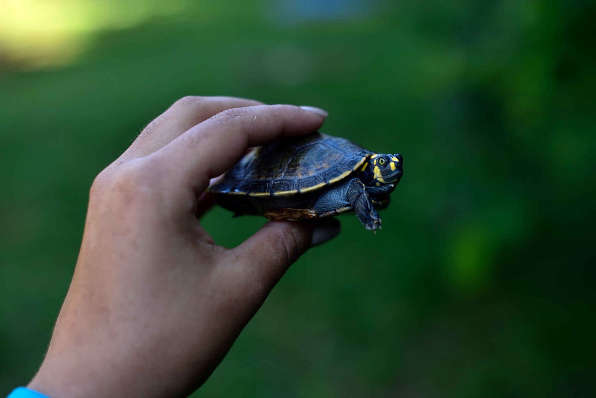
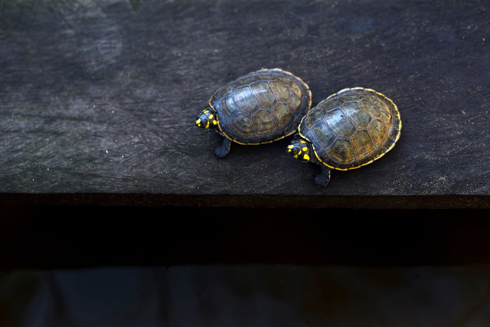
are cared for by local staff at the station, hatching between 65-80 days after being laid. Once the eggs have hatched, the baby turtles are kept in conditioned water ponds to monitor their growth until they are large enough to be released into their natural habitat. Of this batch, 85% of the eggs were hatched.

We have already purchased the tagging equipment to “mark” these turtles so they can be monitored after their release, however, due to political unrest in Bolivia in late 2019 and the current COVID-19 global pandemic that has restricted mobility in the country, they have not yet been released back to the wild. They are, however, being fully cared for at the biological station and staff will release them once restrictions are lifted.

We still expect to carry out one more training event to teach staff and volunteers how to release the turtles and how to monitor the survival, dispersal, and growth of these turtles.

Special thanks to The Sheldon and Audrey Katz Foundation for their generous support that makes this project possible.

Amazon Fire Season Intensifies; Shifts to Raging Forest Fires

Forest Fire in the Brazilian Amazon (Mato Grosso). Data: Planet.We have documented 1,650 major fires in the Brazilian Amazon this year, and well over half (60%) have occurred in September.*

We have been detecting around 62 major fires a day during September, relative to 18 in August (and 2 in July).

Moreover, we flag the major spike in Amazon forest fires, defined here as human-caused fires in standing forest.

We found over 700 forest fires, which now account for 43% of all major fires, up from 13% in August (and just 1% in July).

We roughly estimate that 4.6 million acres (1.8 million hectares) have been impacted by these forest fires in the Brazilian Amazon.

The satellite image to the right is just one example of a recent major forest fire in the Brazilian Amazon. Below, for greater context, we show a before and after panel of that same fire.

Many of the major fires (49%) continue to burn recently deforested areas, defined here as areas where the forest was previously and recently cleared (between 2018 and 2020) prior to burning. This percentage, however, was much higher earlier in the fire season (For example, 84% in July).

Check out Mongabay’s real-time Brazilian Amazon fire tracker based on our analysis.

*The data, updated through September 20, is based on our novel real-time Amazon Fires Monitoring app, which is based on the detection of elevated aerosol emissions that indicate the burning of large amounts of biomass (defined here as a “major fire.”

Satellite Images of Amazon Forest Fires

The following high-resolution satellite images (courtesy of Planet) show the before (left panel) and after (right panel) of a recent major fire in the Brazilian Amazon (Mato Grosso state). Further below is another panel zooming out to show the surrounding matrix of forest fires, recently deforested area fires, and cropland fires.

Acknowledgements

The app was developed and updated daily by Conservación Amazónica (ACCA). The data analysis is led by Amazon Conservation in collaboration with SERVIR Amazonia.


Citation

Finer M, Vale H, Walker K, Villa L, Nicolau A, Ariñez A  (2020) Amazon Fire Season Continues to Intensify in September. MAAP.

Helping Create Two Conservation Areas in Bolivia

Porvenir protected areaFor the past year, we had been working on legal and technical requirements needed to create the 78,000-acre Porvenir Protected Area in the Pando region of Bolivia, and on creating the necessary framework to support its long-term management and protection. This work paid off; even with the challenges of the pandemic, the municipal government has officially declared Porvenir a protected area in early October. Additionally, another protected area nearby, Puerto Rico, is in the final stages of being declared and we expect the process to be completed by the end of the year. Together, these two new conservation areas will protect almost 400,000 acres of forests – a major win for the Bolivian Amazon!

In both of these areas, the process for their creation and management requires an important baseline of information on the biodiversity that lives there and on the ecosystem services that they provide (that is, a quantification of the many benefits to humans get from these forest ecosystems). This way, the management of the natural resources of the area will be sustainable and will keep these centuries-old forests healthy and productive. We provided the communities and the local government with this key ecological information, including physical ecosystem information, inventories of flora and fauna, climate analysis, and the identification of threatened species and of species with the potential for sustainable use that could raise families’ income.

Porvenir protected areaGiven the heavy amount of fieldwork needed to create a conservation area, it has been a challenge working within a global pandemic and quarantine restrictions in Bolivia, as it has kept our experts from making the necessary field expeditions to carry out this work. However, we adapted our scientific methodology to continue to move forward given these extraordinary conditions. We developed a survey of all of the studies, literature, and data collections made over the past years and we used geomatic tools (that is, geographic information systems (GIS), remote sensing using satellites, and high-tech drones) to gather data on the groups of flora and fauna in both areas. With this adaptation, we were able to gather sufficient information to support the government in the formal declaration process for Porvenir to become a protected area, and in moving forward to do the same for the Puerto Rico area.


Special thanks to Andes Amazon Fund (AAF), the Sheldon and Audrey Katz Foundation, and all individuals and organizations whose generous support made this project possible.

New Technology Helps Find and Stop Deforestation Using Sound

High in the treetops of our Los Amigos Conservation Concession, two listening devices powered by solar panels transmit real-time sounds of the rainforest to local rangers’ phones, and across the world.

These acoustic monitoring devices transmit a short recording of any unusual sounds through local cell towers to get to a cloud database, where different forest sounds are classified using machine learning techniques. Incoming audio plug into these high-tech detection models where they can be distinguished between normal sounds one expects to hear in a rainforest – like a jaguar growl or different bird songs – and potential illegal activities caused by humans – like a chainsaw or small tractor. The sounds captured are then sent to the cellphones of park rangers, local advocates, and indigenous leaders where they can hear the sound to confirm the findings and know the exact location of where it’s happening so they can take action. All of this happens within seconds. 

Photo of Topher WhiteThe dense forests of Los Amigos are one of the few rainforest locations around the world piloting this innovative listening technology to detect deforestation in real-time. The project, led by Rainforest Connection’s founder Topher White, has partnered with us to test this technology so deforestation can be discovered, reported and stopped before it reaches a point of no return.

For example, when the real-time acoustic monitoring devices record a sound of what could potentially be a chainsaw cutting down trees, our forest rangers on the ground and our staff of experts around Peru receive an alert on their phones notifying them that trees may be being cut in our protected area at that very moment. Rangers then listen to the audio clip and can confirm via the app, based on their extensive experience living and working in the rainforest, that it is indeed a chainsaw that they hear in the recording. If confirmed, we are able to use drones and satellite images in that location to record evidence of illegal activity – without risking the lives of our forest rangers in confrontations with perpetrators – and report the illegal activity to the authorities who can take the appropriate legal and enforcement actions.


Setting Up at Los Amigos

“Los Amigos is the perfect place to test out novel technologies like acoustic monitoring,” says Topher, “it’s really a laboratory to experiment with new conservation ideas.”

For Rainforest Connection’s technology to work, it’s essential to have local cell phone towers and networks to capture and transmit the audio. “The Los Amigos Conservation Hub in Peru has these amazing towers that were built 15 years ago that are ideal to transmit the information,” Topher adds, “This existing infrastructure helped cut our work, and we could focus on just building the cell phone networks powered with solar panels.” 

Some of that technology also needed to be installed in trees near the acoustic recording devices, Topher counted on the help of one of our researcher friends and expert tree-climber, Andy Whitworth from Osa Conservation, to climb Los Amigos’ incredibly tall trees and install two solar panels boxes and cell phone network extenders.

Despite the challenges in keeping the cell phone grid and the monitoring devices powered, secured, and connected to the world via the internet, the potential benefits of keeping forests safer without exposing park guards to dangerous situations kept Topher and Andy going while they were climbing dozens of trees to install the recording devices. “This type of technology still takes a lot of field work,” says Andy, “but it can provide so much for the protection and understanding of these forests in the long run. It’s worth it.”


More to Come: Using Sounds to Advance Science

Aside from recording deforestation-related sounds, the acoustic monitoring devices capture a lot of additional, valuable biodiversity data. As the recordings are hosted in a cloud database, it has the potential of becoming a rich source for baseline data for scientists conducting scientific studies on the Amazon. 

For instance, if a scientist wants to track the presence of a particular bird species in an area over a span of a few months or years, they can refer to the audio library as a baseline resource for hearing the movements and quantity of calls of that species in the lowland forests of Los Amigos. By referencing and sourcing from this vast library of acoustic information, researchers can contribute to our understanding of the biodiversity of the Amazon without having to set foot in it. Topher likens the database as a “Google Earth for acoustic data.” 

On the prospect of expanding this technology to other uses, Topher comments that “sound is the most exciting piece of data available to us that’s not been fully realized for protecting the planet. You look at all the ways satellite imagery has helped us monitor the environment, I believe the next revelation will be in acoustics.”

“With acoustic monitoring, we can even hear things happening that don’t necessarily make a noise, as we can hear the other animals’ response to it. We’re just getting started, and the future involves getting others to be a part of it.”

Brazilian Amazon Fires Intensify in September

Although August was severe, early September saw the Brazilian Amazon fires intensify even more.

September shot up to an average of 53 major fires per day across the Brazilian Amazon, up from 18 in August (and 2 in July).*

In addition, the surrounding Pantanal, the world’s largest tropical wetlands, is experiencing unprecedented fires.

The Base Map shows major fires scattered across the Brazilian Amazon in relation to the huge fire complex to the south in the Pantanal, as seen in our novel real-time fire monitoring app from early September.

Base Map. Amazon fires in relation to Pantanal fires as seen in our Real-time Amazon Fire Monitoring app (September 6). Red indicates most severa fires. Data: MAAP/ACCA.

Red indicates the most intense fires burning the highest levels of biomass.

Overall, we have now detected 963 major fires this year in the Brazilian Amazon with the app.

*Data updated through September 7, 2020.


Increase in Amazon Forest Fires

Also noteworthy is the major spike in Amazon forest fires, defined here as human-caused fires in standing forest. Forest fires now account for a striking 27% of all major fires, up from 13% in August (and 1% in July).

An estimated 896,000 acres (362,000 hectares) have been impacted  by these Amazon forest fires.

The majority of the major fires (66%) continue to burn recently deforested areas, defined here as areas where the forest was previously and recently cleared (between 2018-20) prior to burning.

In fact, over 1.3 million acres (540,000 hectares) of recently deforested areas has burned in 2020.

A major forest fire in the Brazilian Amazon (Mato Grosso) on September 6, 2020. Data: Planet. Analysis: MAAP/ACCA, SERVIR.

Thus, most of the fires are actually a smoking indicator of the current rampant deforestation in the Brazilian Amazon.


Protected Areas and Indigenous Territories

We also must highlight that we have detected 80 major fires in protected areas and indigenous territories of the Brazilian Amazon. The most impacted areas are the Xingu and Kayapó indigenous territories, and Jamanxim National Forest.

Major Fires (orange dots) within and around indigenous territories (bright green) and protected areas (light green) in the eastern Brazilian Amazon. Data: MAAP.


*Notes and Methodology

Our novel Real-time Amazon Fire Monitoring app

Data updated as of September 7, starting from the first major fire detected on May 28.

We detected 569 major fires during August in the Brazilian Amazon.

Prior to August, we detected only one forest fire, and that was on July 31.

The app specializes in filtering out thousands of the traditional heat-based fire alerts to prioritize only those burning large amounts of biomass (defined here as a major fire).

In a novel approach, the app combines data from the atmosphere (aerosol emissions in smoke) and the ground (heat anomaly alerts) to effectively detect and visualize major Amazon fires.

When fires burn, they emit gases and aerosols. A new satellite (Sentinel-5P from the European Space Agency) detects these aerosol emissions. Thus, the major feature of the app is detecting elevated aerosol emissions which in turn indicate the burning of large amounts of biomass. For example, the app distinguishes small fires clearing old fields (and burning little biomass) from larger fires burning recently deforested areas or standing forest (and burning lots of biomass).

We define “major fire” as one showing elevated aerosol emission levels on the app, thus indicating the burning of elevated levels of biomass. This typically translates to an aerosol index of >1 (or cyan-green to red on the app). To identify the exact source of the elevated emissions, we reduce the intensity of aerosol data in order to see the underlying terrestrial heat-based fire alerts. Typically for major fires, there is a large cluster of alerts. The major fires are then confirmed, and burn areas estimated, using high-resolution satellite imagery from Planet Explorer.

See MAAP #118 for additional details on how to use the app.

No fires permitted in the Brazilian state of Mato Grosso after July 1, 2020. No fires permitted in all of Brazilian Amazon after July 15, 2020. Thus, we defined “illegal” as any major fires detected after these respective dates.

A major fire may be classified as burning across multiple land categories (for example, both recently deforested area and surrounding forest fire) so those percentages do not total 100%.

There was no available Sentinel-5 aerosol data on July 4, 15, and 26.


Acknowledgements

The app was developed and updated daily by Conservación Amazónica (ACCA). The data analysis is led by Amazon Conservation in collaboration with SERVIR Amazonia.


Citation

Finer M, Vale H, Villa L, A. Ariñez, Nicolau A, Walker K (2020) Brazilian Amazon Fires Intensify in September. MAAP.