New MAAP Report Details Deforestation in Protected Areas and Indigenous Territories of the Colombian Amazon
April 23, 2025
In 2023, we published a MAAP report detailing the effectiveness of protected areas and Indigenous territories across the Amazon, which have shown a 3-fold reduction in deforestation rates compared to areas outside these land designations. While the establishment of these areas proves to be effective, some regions continue to remain vulnerable to illegal deforestation activities.
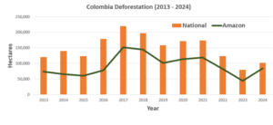
For the past decade, roughly 60% of deforestation in Colombia has occurred in its Amazonian regions. To help address this growing issue, we established a partnership with the Colombian organization, the Foundation for Conservation and Sustainable Development (Fundación para la Conservación y el Desarrollo Sostenible – FCDS), in 2023 to provide MAAP’s real-time deforestation tracking capabilities, enabling swift action against illegal deforestation.
Our newest report, MAAP #224, was created in collaboration with FCDS, following an announcement by the Colombian Ministry of the Environment that detailed the increase in forest clearing rates in 2024, after the country experienced its lowest deforestation in over 20 years. Nearly 1.2 million hectares (approximately 296,500 acres) of the Colombian Amazon have already been deforested (much of it likely illegal) within the past 10 years, occurring in protected areas and Indigenous territories.

MAAP #224 highlights recent deforestation taking place from late 2024 to early 2025 in two key areas of the Colombian Amazon: Chiribiquete National Park (Parque Nacional Natural Serranía de Chiribiquete) and the adjacent Llanos del Yarí–Yaguará II Indigenous Reserve (Resguardo Indígena Llanos del Yarí–Yaguará II). The expansion of road infrastructure, extensive livestock farming, pasture expansion, land grabbing, and illicit crops (coca), have been a identified as the main divers of deforestation in these areas, leading to the loss of over 7,100 hectares (about 17,500 acres) in Chiribiquete National Park alone since its most recent expansion in 2018.
Within the 2024-2024 time period, 525 hectares (about 1,297 acres) of deforestation were estimated in Chiribiquete National Park and an additional 856 (about 2,115 acres) hectares in Llanos del Yarí–Yaguará II Indigenous Reserve.
This report illustrates these key cases of deforestation in both areas through a series of high-resolution satellite imagery and overflight photos to provide greater insight and analysis into the cause of this recent deforestation.
 Loading...