MAAP #97: Deforestation Surge In The Colombian Amazon, 2018 Update

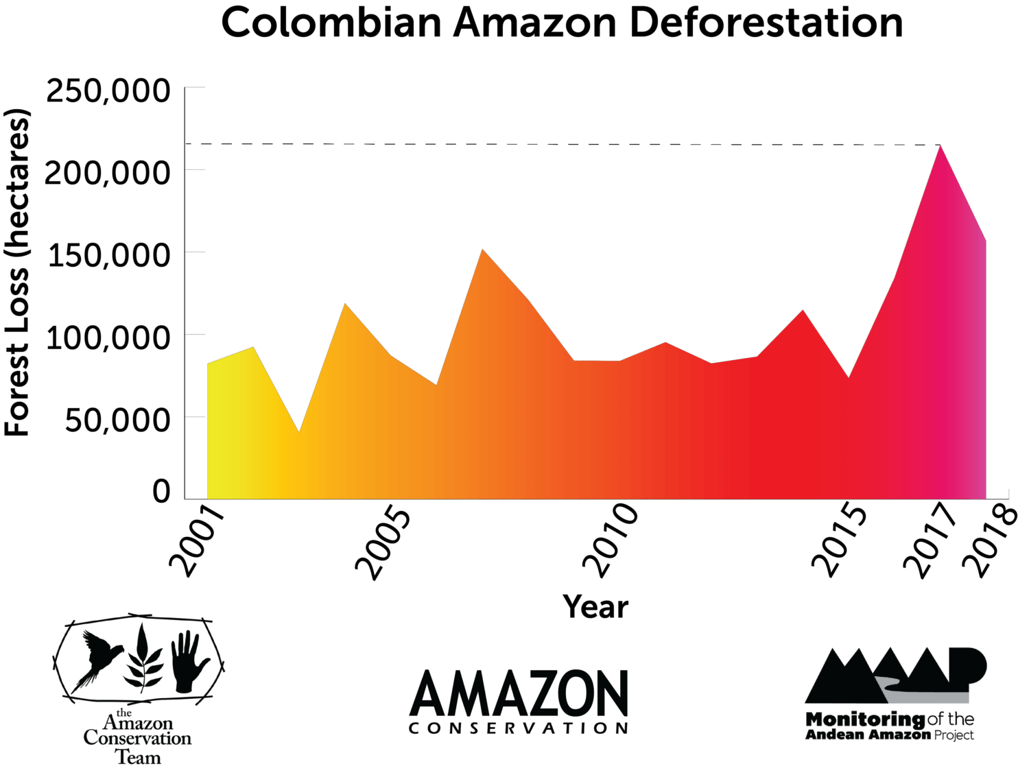
The Colombian Amazon is currently experiencing a deforestation surge (see graph).

The surge started three years ago (2016) and peaked in 2017 with the highest annual deforestation on record (214,744 hectares).*

Deforestation remains high in 2018: 156,722 hectares (based on early warning alert data).* If this estimate is confirmed, it would be the second highest on record (behind just 2017).

National experts indicate that land grabbing (acaparamiento de tierras) is an increasingly dominant direct driver of deforestation.

*Data from the University of Maryland. Annual data from Hansen et al (2013) [citation below] and 2018 data from GLAD alerts.

MAAP Colombia is a collaboration between Amazon Conservation and Amazon Conservation Team., funded by the MacArthur Foundation.

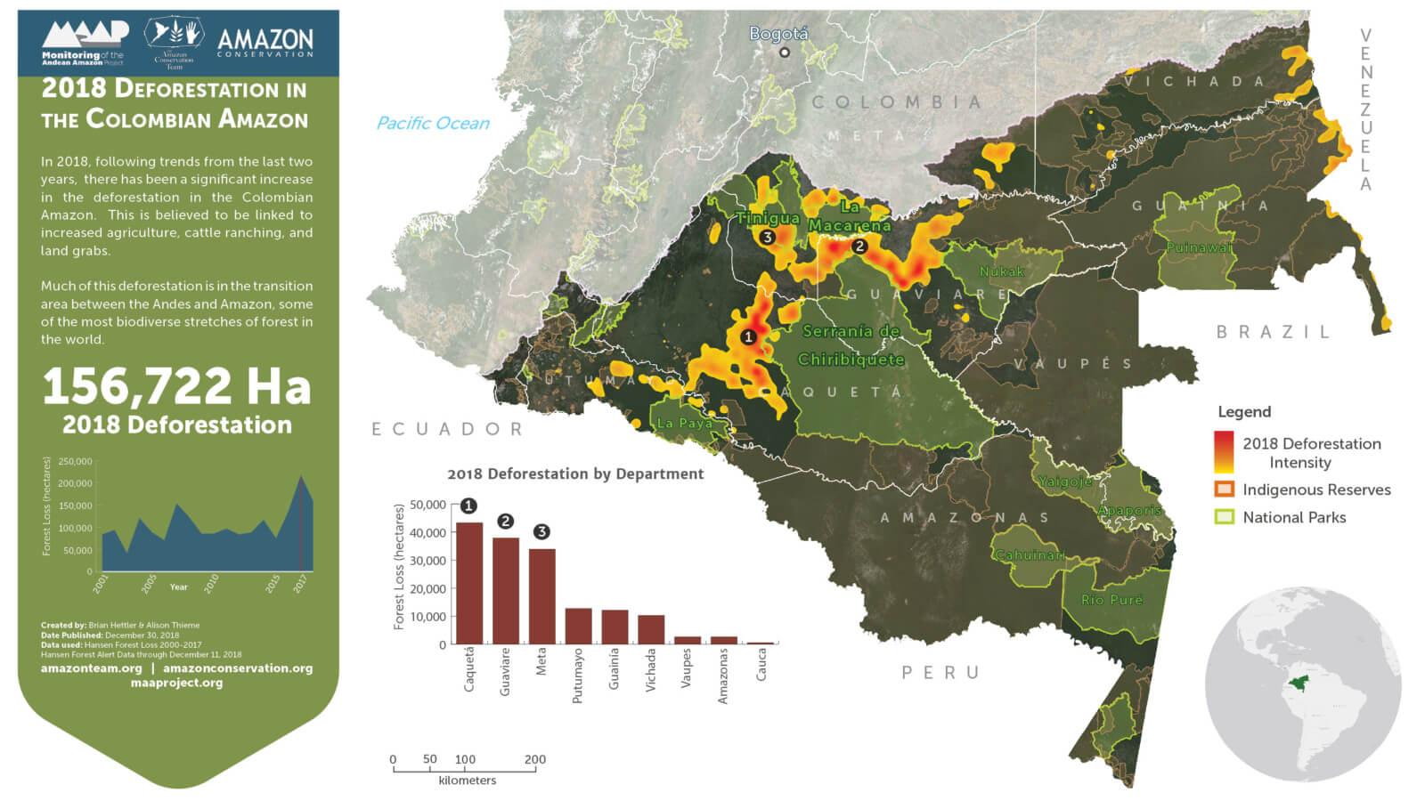
We also present a Base Map that shows the 2018 deforestation hotspots. Note that the deforestation is concentrated in three departments located in the transition area between the Amazon and Andes: Guaviare, Caqueta, and Meta.

We highlight the location of three critical areas that are examined in greater detail below: 1) Llanos de Yari, 2) Chiribiquete- La Macarena, and 3) Tinigua National Park.

For the Base Map and Zooms below, please click on the image to enlarge or download.

Base Map. Deforestation hotspots in the Colombian Amazon. Click to enlarge. Data- UMD:GLAD, Hansen:UMD:Google:USGS:NASA, PNN, SIAC, RAISG

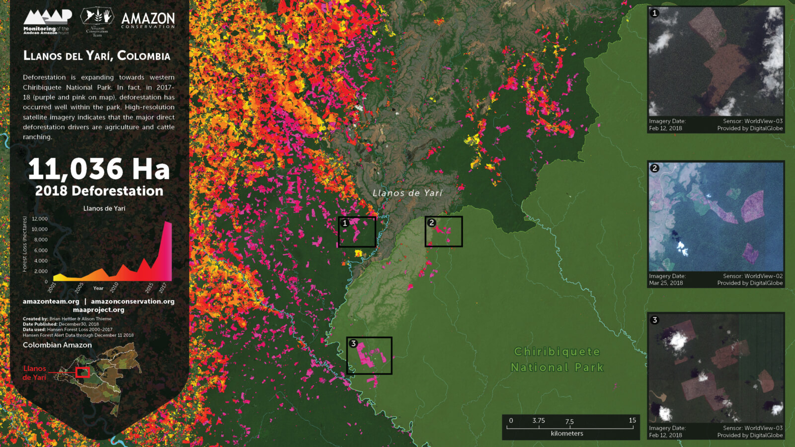
Zoom 1: Llanos de Yari

Zoom 1 shows deforestation expanding towards western Chiribiquete National Park. In fact, in 2017-18 (purple and pink on map), deforestation has occurred well within the park. 

Zoom 1. Llanos de Yari. Click to enlarge. Data- DigitalGlobe, UMD:GLAD, Hansen:UMD:Google:USGS:NASA, PNN, SIAC, RAISG

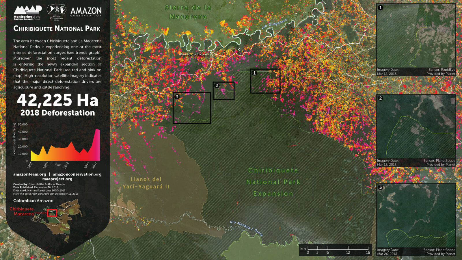
Zoom 2: Chiribiquete – La Macarena

As we first reported in MAAP #86, the area between Chiribiquete and La Macarena National Parks is currently experiencing one of the most intense deforestation surges. Zoom 2 shows the most recent deforestation (indicated in red and pink) is entering the newly expanded section of Chiribiquete National Park. 

Zoom 2. Chiribiquete – La Macarena. Click to enlarge. Data- Planet, UMD:GLAD, Hansen:UMD:Google:USGS:NASA, PNN, SIAC, RAISG.

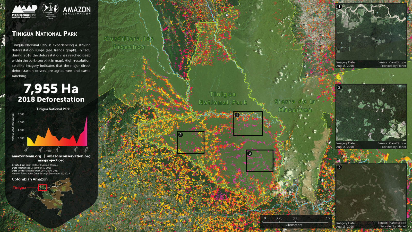
Zoom 3: Tinigua National Park

Zoom 3 shows how 2018 has seen a surge of deforestation deep within Tinigua National Park (see pink). 

Zoom 3. Tinigua National Park. Click to enlarge. Data- Planet, UMD:GLAD, Hansen:UMD:Google:USGS:NASA, PNN, SIAC, RAISG

References

Planet Team (2017). Planet Application Program Interface: In Space for Life on Earth. San Francisco, CA. https://api.planet.com

Hansen, M. C., P. V. Potapov, R. Moore, M. Hancher, S. A. Turubanova, A. Tyukavina, D. Thau, S. V. Stehman, S. J. Goetz, T. R. Loveland, A. Kommareddy, A. Egorov, L. Chini, C. O. Justice, and J. R. G. Townshend. 2013. “High-Resolution Global Maps of 21st-Century Forest Cover Change.” Science 342 (15 November): 850–53. Data available on-line from:http://earthenginepartners.appspot.com/science-2013-global-forest.


Citation

Hettler B, Thieme A, Finer M (2018) Deforestation Surge in the Colombian Amazon: 2018 update. MAAP: #96.

Patterns, trends and drivers of deforestation in the Peruvian Amazon: What you need to know 

As the world’s largest rainforest covering nine countries, the Amazon rainforest has been known as Earth’s lungs for generations. However, as a resource-rich forest, it continues to be deforested at staggering rate. To combat that, our MAAP project was launched over 2 years ago to help not only monitor the deforestation in the Peruvian Amazon in near real-time, but also to empower local authorities with key information so they can act before it gets to a point of no return. So far 50 MAAP threat alerts have been issued. Here is what we have learned about the patterns, trends and drivers of deforestation in this key area of the Amazon rainforest.

Trends – What has been the progression of deforestation?
During the 15 years between 2001 and 2015, around 4,448,000 acres of Peruvian Amazon forest have been deforested, with a steadily increasing trend. 2014 had the highest annual forest loss on record (438,775 acres), followed by a slight decrease  in 2015. The preliminary estimate for 2016 indicates that forest loss remains relatively high. The vast majority (80%) of forest loss events in the Peruvian Amazon are small-scale (<13 acres), while large-scale events (>125 acres) pose a latent threat due to new agro-industrial projects.

Hotspots –  Where is the deforestation taking place?
We have identified at least 8 major deforestation hotspots. The most intense hotspots are located in the central Amazon (Huánuco and Ucayali) of Peru. Other important hotspots are located in Madre de Dios and San Martin, two areas that have long been plagued by illegal gold mining. Two legally protected conservation areas (Tambopata National Reserve and El Sira Communal Reserve) are currently threatened by these hotspots, since invasions to these protected areas are not uncommon.

Drivers – What are the key factors that are driving deforestation? 
By analyzing high-resolution satellite imagery, we have documented six major drivers of deforestation and degradation: small/medium-scale agriculture, large-scale agriculture, cattle pasture, gold mining, illegal coca cultivation, and road creation. Small-scale agriculture and cattle pastures are likely the most dominant drivers of deforestation overall. Gold mining is a major driver in southern Peru. Large-scale agriculture and major new roads are latent threats. Logging roads are likely a major source of forest degradation in central Peru.

Check out a full analysis with graphics over at http://maaproject.org/2017/maap-synthesis2/