Image #10: Bahuaja Sonene National Park – Increasing Deforestation Within and Around Southern Section (Puno, Peru)

Here, in MAAP #10, we show the results of a deforestation analysis of two sectors of Bahuaja Sonene National Park and its surrounding buffer zone. The Park, which covers an area of more than 1.6 million hectares in the regions of Puno and Madre de Dios in the southern Peruvian Amazon, is an area of high biological diversity.

Specifically, we found increasing deforestation in 1) the buffer zone of the Park’s western section (Loromayo sector) and 2) inside the Park’s southeastern section (Colorado sector). In both cases, we identified shifting cultivation associated with coca cultivation as one of the main drivers of deforestation.
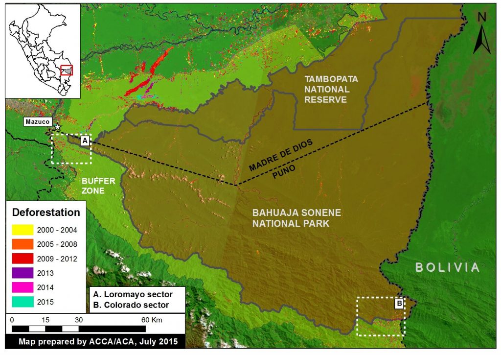
Image 10a. Deforestation detected in and around Bahuaja Sonene National Park and its buffer zone. Please note that Zooms “A” and “B” are described in more detail below. Data: SERNANP, PNCB, USGS.

Key Results

We highlight two key areas within and around Bahuaja Sonene National Park where deforestation grew substantially between 2013 and 2015:

1) Sector Loromayo, located in the buffer zone immediately outside the western section of the Park (see Zoom A). We estimate that more than 1,000 hectares (ha) were deforested since 2010, peaking in 2014 (331 ha). This expanding deforestation entered the Park in 2014.

2) Sector Colorado, located in the southeastern section of the Park (see Zoom B). We estimate, between 2001 to 2014, the deforestation of over 530 hectares inside the Park and over 1,170 hectares in the surrounding buffer zone. As in Loromayo, there was a notable increase in deforestation starting in 2010, with the peak occurring in 2014.

In both sectors, Loromayo and Colorado, we identified that one of the main drivers of deforestation is coca cultivation.

Description of Data

In the following maps:

Any variation of green in the satellite imagery indicates areas of forest cover.

Yellow (2000-2004), orange (2005-2008), red (2009-2012), and purple (2013) indicate areas that were deforested between 2000 and 2013 according to data from the National Program of Forest Conservation for the Mitigation of Climate Change (PNCB) of the Ministry of the Environment of Peru.

The colors pink (2014) and turquoise (2015) indicate areas that were deforested in the last two years based on our analysis of Landsat imagery using CLASlite forest monitoring software.

Zoom A: Loromayo River (western buffer zone)
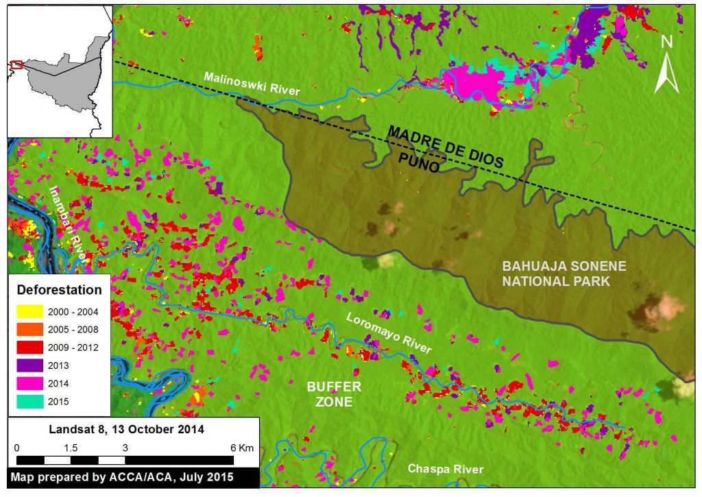
 

Image 10b. The expansion of deforestation along the Loromayo river in the buffer zone to the west of Bahuaja Sonene National Park. Data: SERNANP, USGS, IBC, PNCB.

As shown in Figure 10b, we identified a striking pattern of deforestation in the sector Loromayo, located between the Malinowski and Chaspa rivers in the Park’s western buffer zone in the department of Puno. Note that the deforestation entered the Park in 2014.

In this area, we documented the deforestation of 1,005 hectares since 2010. This deforestation peaked in 2014, with 331 hectares, including 1.8 hectares within the Park. Not much data is yet available for 2015.

Please note that we previously reported on the advance of gold mining deforestation seen in Image 10b along the Malinowski River in MAAP #5.

Sector Loromayo: Shifting Agriculture that includes Coca Cultivation
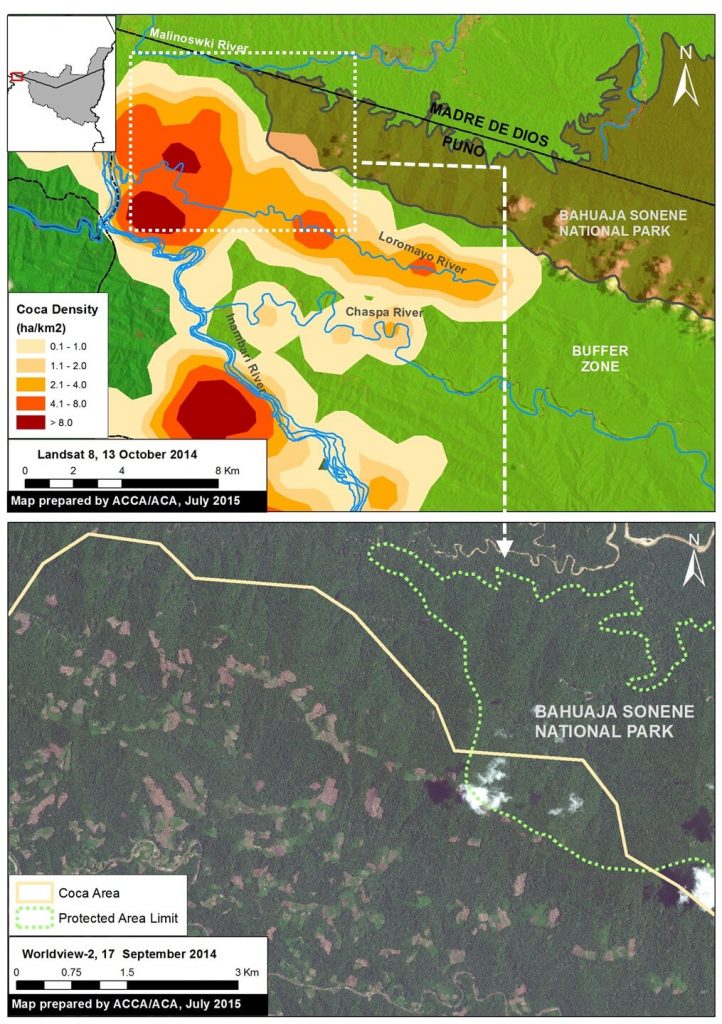
 

Image 10c. Coca density data (upper panel) in relation to a recent high resolution satellite image of the area (lower panel). Data: UNODC 2014, SERNANP, Worldview-2 from Digital Globe (NextView).

In the recent UNODC (United Nations Office on Drugs and Crime) report “Monitoreo de Cultivos de Coca 2014” [Coca Crop Monitoring 2014], it was reported that the Loromayo sector (coca zone San Gabán) has a medium to high density of coca cultivation, with a recent increase of 5.9% since 2013. Therefore, we conculde that coca cultivation is one of the major drivers of the observed deforestation.

Image 10c displays the most recent UNODC coca density data (upper panel) in relation to a recent high resolution satellite image of the area (lower panel). Deforestation is rapidly expanding in the vicinity of the Park boundary. Unfortunately, in this image, a few clouds cover the small area where the deforestation recently entered Park.

Zoom B: Sector Colorado (Southeastern section of Park)
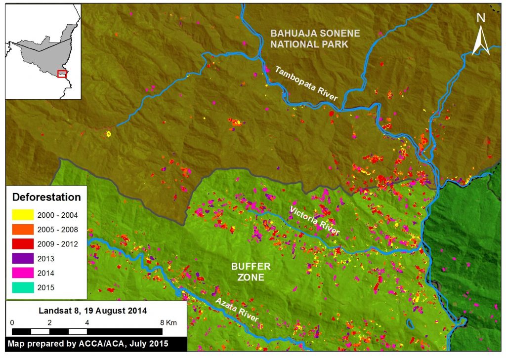
Image 10d. The expansion of deforestation in the Colorado sector of Bahuaja Sonene National Park. Data: SERNANP, USGS, IBC, PNCB.

As seen in Figure 10d, deforestation is well established and increasing in the sector Colorado, located in the southeast section of Bahuaja Sonene National Park, with the Region of Puno. Our analysis in this area extended from the upper Tambopata River to the Azata river.

We document the deforestation, since 2001, of 538 ha inside the Park and an additional 1,172 ha within the surrounding buffer zone. Similar to the sector Loromayo sector, there was a marked increase in deforestation since 2010, with a peak in 2014. More than half of the deforestation (53%, 287 ha) occurred since 2010, with a maximum of 81 ha in 2014. Not much data is yet available for 2015.

Sector Colorado: Presence of Coca Cultivation Inside the Park
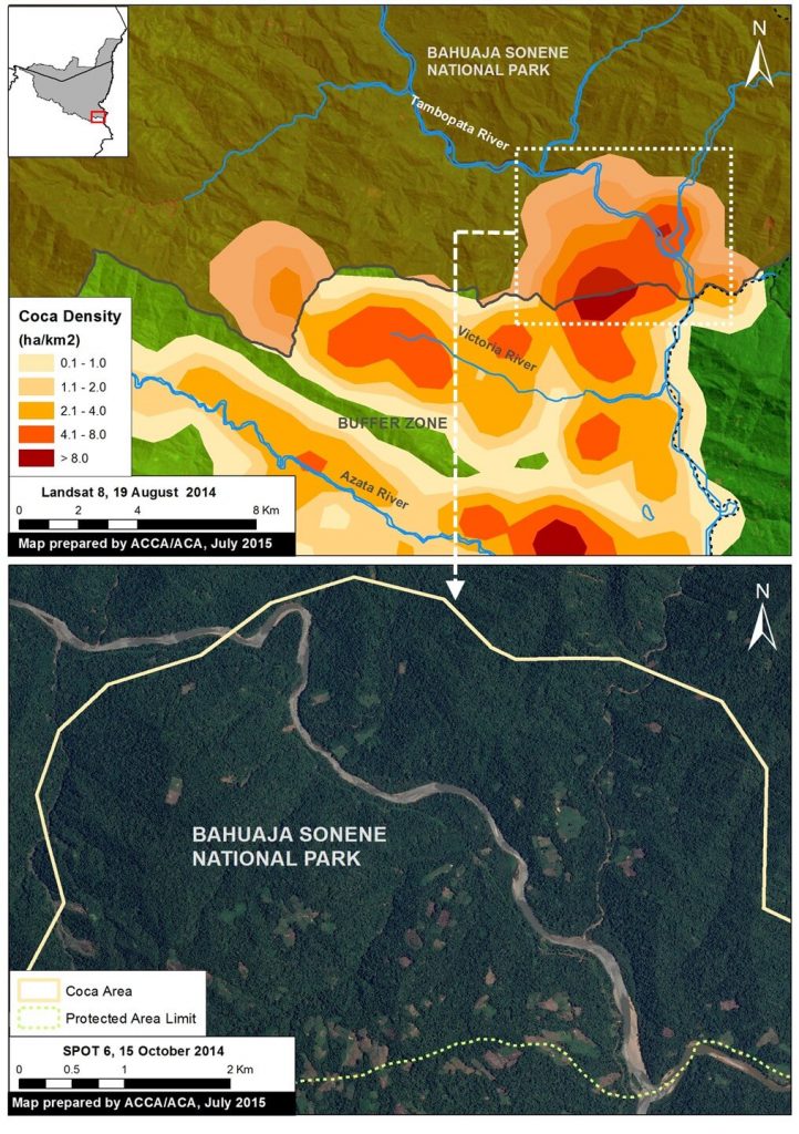
 

Image 10e. Coca density data (upper panel) in relation to a recent high resolution satellite image of the area (lower panel). Data: UNODC 2014, SERNANP, SPOT6 from Airbus.

According to a recent report by the Wildlife Conservation Society (WCS), the deforestation in the Colorado sector was a result of the advance of agriculture and livestock cultivation in the area. Moreover, according to the recent UNODC report noted above, this sector (coca zone Inambari-Tambopata) also has a high density of coca, with 108 ha on the interior of Bahuaja Sonene National Park and 1,610 ha in the buffer zone, likely making it one of the major drivers of the observed deforestation.

Image 10e displays the UNODC coca density data (upper panel) in relation to a recent high resolution satellite image of the area (lower panel).

SERNANP Response

In response to this article, SERNANP (the Peruvian protected areas agency) issued this statement:

“El sector denominado como Colorado es sector ubicado dentro del Parque Nacional Bahuaja Sonene, que actualmente se encuentra zonificado como Zona de Recuperación; dicha zonificación se otorga a aquellas zonas que por actividades antrópicas han sido afectadas y que necesitan estudios complementarios para determinar su zonificación definitiva.”

[The sector named ‘Colorado’ is a sector located within the Bahuaja Sonene National Park, which currently is zoned as a ‘Restoration Zone.’ Said zoning is extended to those zones which have been affected due to anthropic activities and require supplementary studies so as to determine their definitive zoning designation.] Debemos señalar que en este sector se han detectado severas plagas que afectan los cultivos de frutos como la naranja y café, desencadenando que la población asentada en la zona de amortiguamiento del Parque se vean forzada a reemplazar estas plantaciones por el cultivo de coca en algunos casos.

[We should note that severe pests have been detected in this sector which affect the cultivation of fruit such as oranges and coffee; this has lead the population settled in the park’s buffer zone to have no choice but to replace these crops with the cultivation of coca in some cases.] Esta situación ha sido identificada y advertida oportunamente por el jefe del Parque Nacional Bahuaja Sonene a las entidades pertinentes para iniciar su erradicación; no obstante, el SERNANP también ha emprendido un trabajo conjunto con las autoridades locales y el comité de gestión del área natural protegida para combatir esta amenaza, lo cual figura en el Plan Maestro 2015-2019 del área en mención. Ahí se contemplan estrategias como la construcción de un puesto de control y vigilancia para monitorear permanentemente esta situación.

[The head of the Bahuaja Sonene National Park has identified and issued a warning about this situation in a timely manner to the relevant entities so as to initiate its eradication work; notwithstanding, SERNANP has also undertaken joint work with local authorities and the management committee of the natural protected area to combat this threat, which figures in the 2015-2019 Master Plan of the area in question. The latter contains strategies such as the construction of a checkpoint and guard post for permanently monitoring this situation.] Asimismo, se vienen promoviendo mesas de diálogo y el desarrollo de actividades económicas sostenibles que reemplacen los cultivos ilícitos y que garanticen la calidad de vida de la población de Colorado.”

[Likewise, dialogue roundtables and the development of sustainable economic activities have been promoted that can replace the illicit crops and guarantee quality of life for the population of Colorado.]

Citation

Finer M, Novoa S (2015) Bahuaja Sonene National Park – Increasing Deforestation Within and Around the Southern Section (Puno, Peru). MAAP: Image #10. Link: https://maaproject.org/2015/07/image-10-bahuaja/

References

UNODC. Monitoreo de cultivos ilícitos Perú 2014. p 29. (Lima, 2015).

Image #8: New Deforestation Detected Within Sierra Del Divisor (Peru) in June

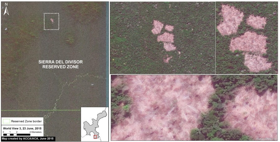
Recall that in Image of the Week #7 we documented the increasing threats (illegal coca, logging, and mining) to the Sierra del Divisor Reserved Zone. We just obtained brand new, high-resolution imagery showing new deforestation deep within this protected area during the month of June. Here, Image of the Week #8, presents new maps of this recent deforestation. According to several consulted experts, the cause of this deforestation is illegal coca cultivation or a new illegal logging camp.

Image 8a: Very high resolution (38 cm) image from June 23 showing new deforestation within the Sierra del Divisor Reserved Zone. Data: WorldView-3 from Digital Globe (NextView).

New Deforestation Detected

Image 8a shows the new deforestation detected within the southeast section of the Sierra del Divisor Reserved Zone. As of June 23, 2015 (the date of the image), the total new deforestation was 13 hectares. This deforestion is located between the La Cúpula and Shesha hills.

In Image of the Week #7 we showed that there is a series of illegal logging camps nearby, but this new deforestation is located much deeper in the reserve. According to several consulted experts, the cause of the new deforestation is illegal coca cultivation or a new illegal logging camp.

Updated Baseline Map


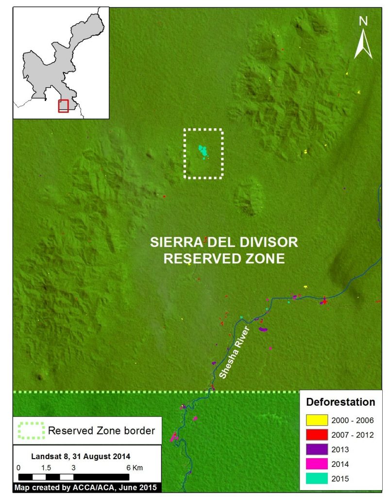
Image 8b. Updated baseline map of the southeast section of the Sierra del Divisor Reserved Zone. Data: MINAM, SERNANP, USGS, IBC, Hansen/UMD/Google/USGS/NASA.

Image 8b is an updated map of the deforestation within the southeast section of the Sierra del Divisor Reserved Zone. Note that the new 2015 deforestation is found much deeper within the reserve than previous detected forest loss.

Confirming Recent Deforestation


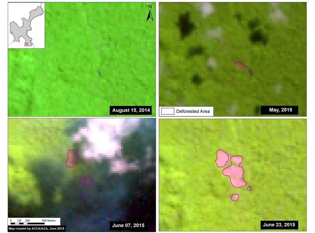
Image 8c. Landsat time-series (2014-2015) of the recent deforestation. Data: USGS.

To better understand how the recent deforestation unfolded, we created a satellite (Landsat) image time-series. Note that in Image 8c all four panels show the exact same area over time. In August 2014, our focal area was completely forested. The first evidence of deforestation is seen in May 2015. In June 2015, the deforestation grows quickly.

Deforestation Within the Isconahua Territorial Reserve

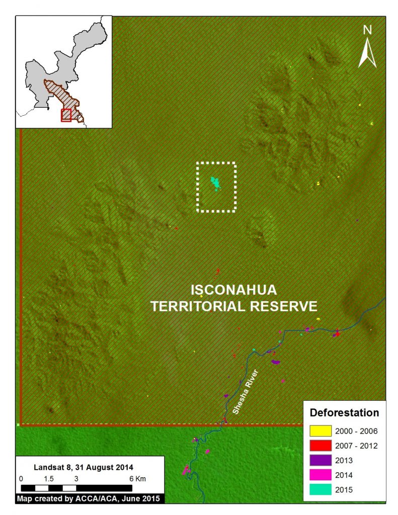
Image 8d. Deforestation within the Territorial Reserve Isconahua. Data: MINAM, SERNANP, USGS, IBC, Hansen/UMD/Google/USGS/NASA.

Image 8d shows the new deforestation is also located with the Isconahua Territorial Reserve.

This is an official land designation in favor of indigenous peoples in isolation, to protect their rights, habitat, and the conditions that ensure their existence and integrity as a people.

SERNANP Response

In response to this article, SERNANP (the Peruvian protected areas agency) issued this statement:

“The Sierra del Divisor Reserved Zone is a transitional area under the Peruvian National Service of Natural Protected Areas (SERNANP).

Over the past few years, Sierra del Divisor has made significant efforts in its fight against ilegal logging and other activities that threaten it. However, it is worth noting that Image of the Week #8: New Deforestation Detected Within Sierra del Divisor (Peru) in June corresponds with an area of overlap with the Isconahua Territorial Reserve, a sector in which the Ministry of Culture works in coordination with SERNANP.

As part of our actions, SERNANP has planned a flyover in the zone to verify information regarding the new deforestation alert in the Sierra del Divisor, and will continue with special park guard patrolling that began last week, despite the local climate conditions.”

+++

“La Zona Reservada Sierra del Divisor es un espacio de carácter transitorio a cargo del Servicio Nacional de Áreas Naturales Protegidas por el Estado (SERNANP).

En los últimos años la ZRSD ha realizado grandes esfuerzos en su lucha contra la tala ilegal y otras actividades que la amenazan. Sin embargo, hay que precisar que la Imagen de la Semana #8: Nueva Deforestación al Interior de la ZRSD corresponde al ámbito de traslape (superposición) con la Reserva Territorial Isconahua, donde también interviene el Ministerio de Cultura, la cual el SERNANP trabaja de manera conjunta con dicho sector.

En el marco de nuestras acciones, el SERNANP viene programando un sobrevuelo en la zona para verificar la información sobre la nueva alerta de deforestación en la ZRSD, y continuar con el patrullaje especial del personal guardaparque que viene realizando desde la semana pasada, pese a las condiciones climáticas del lugar”.

Citation

Finer M, Novoa S, Peña N (2015) Nueva Deforestación al Interior de la Zona Reservada Sierra del Divisor. MAAP: Imagen #8. Link: https://maaproject.org/2015/06/imagen-8-sierradivisor

Image #6: Expanding Gold Mining Deforestation Enters Amarakaeri Communal Reserve (Madre De Dios, Peru)

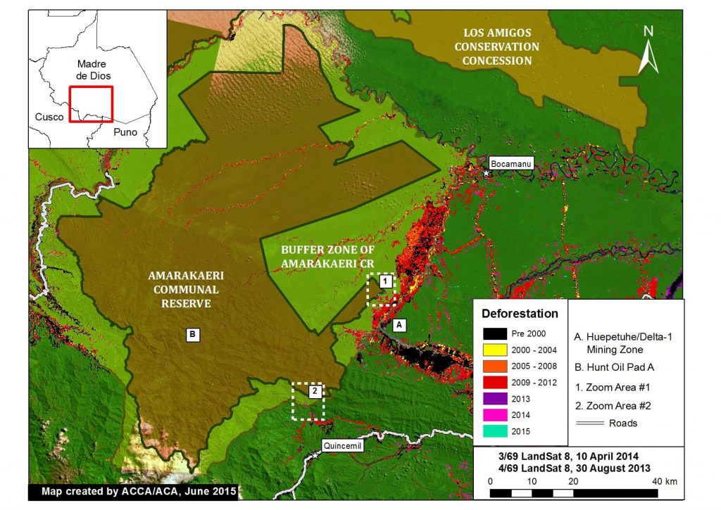
Recall that in Image of the Week #1 and Image of the Week #5 we documented how gold mining deforestation continues to expand within the Department of Madre de Dios, Peru (in the areas known as La Pampa and Upper Malinowski, respectively). Here, Image of the Week #6 documents how expanding deforestation from the mining zone known as Huepetuhe/Delta-1 is now entering the Amarakaeri Communal Reserve, an important Peruvian protected area that is co-managed by indigenous communities and Peru’s National Protected Areas Service (known as SERNANP).
Our analysis shows that gold mining deforestation, expanding from Huepetuhe/Delta-1, entered the southeast corner of the reserve in 2013 and expanded in 2014 and 2015. We also show that gold mining deforestation is spreading within the reserve’s south-eastern buffer zone.

Image of the Week 6a. Deforestation detected within and around the Amarakaeri Communal Reserve and its buffer zone. Zoom Area #1 indicates focal area in Images 6b and 6c, while Zoom Area #2 indicates focal area in Image 6d. Key data sources: MINAM, SERNANP, ACCA, USGS, IBC, Hansen/UMD/Google/USGS/NASA.

Key Findings:

According to our CLASlite analysis, deforestation entered the southeast corner of the Amarakaeri Communal Reserve in 2013 and expanded in 2014 and 2015 (see Zoom #1 below). Additional analysis revealed that the driver of this deforestation was gold mining due to the pattern and appearance of the forest loss.

We also detected increasing gold mining deforestation within the reserve’s south-eastern buffer zone between 2014 and 2015 (see Zoom #2 below). See below for more details.

We also detected a small amount of deforestation in 2014 from Hunt Oil’s drilling of Pad A within the reserve (see “B” in Image 6a). Note that overall deforestation from this gas exploration project has been very low because the company did not build an access road.

Gold Mining Deforestation Enters the Reserve (Zoom Area #1)

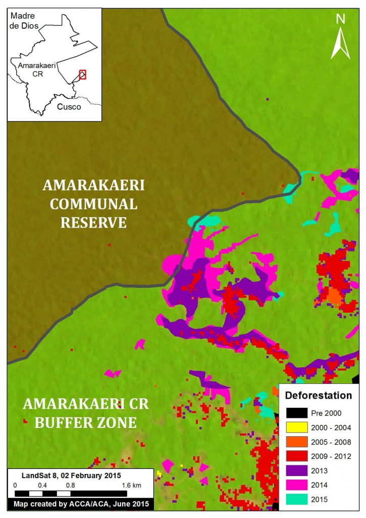
Image 6b. Zoom Area #1 provides an enhanced view of the deforestation within the southeast section of Amarakaeri Communal Reserve and its surrounding buffer zone. Key data sources: MINAM, SERNANP, ACCA, Hansen/UMD/Google/USGS/NASA, USGS.

Image 6b is a zoom view of the deforestation within the southeast section of Amarakaeri Communal Reserve and its surrounding buffer zone (see Zoom Area #1 in Image 6a for context).

Here, one can more clearly see how the gold mining deforestation entered the southeast corner of the reserve in 2013 and expanded in 2014 and 2015.

Total gold mining deforestation within this section of the Reserve is currently 11 hectares. Although this is currently only 1% of the Reserve’s total area, it represents a growing trend that may worsen.

Note that all of the rest of the deforestation in the image is within the reserve’s surrounding buffer zone.


Satellite Image Time-series of Deforestation Entering the Reserve (Zoom Area #1)

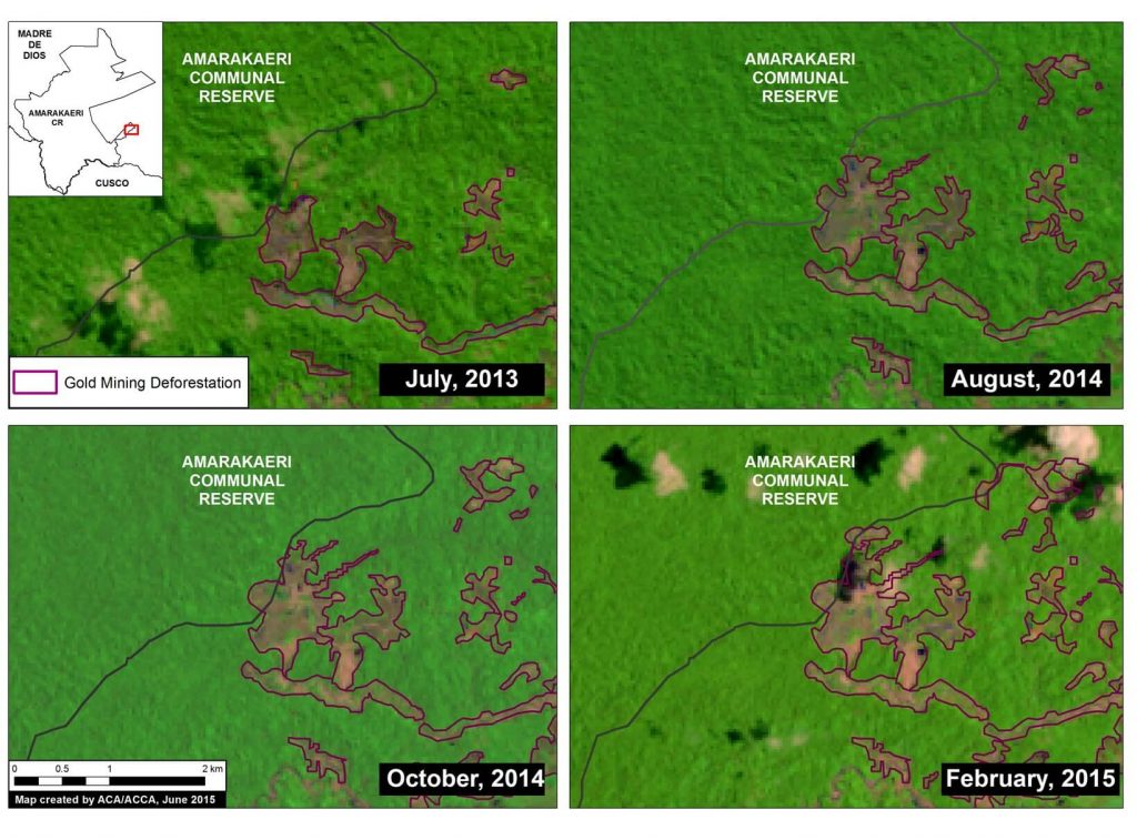
Image 6c. Satellite (Landsat 8) image time-series (2013 – 2015) of deforestation within the southeast section of the Amarakaeri Communal Reserve. Note that all four panels show the same location over time. Key data sources: USGS, SERNANP.

To better understand the deforestation dynamics over time within the southeast corner of the Amarakaeri Communal Reserve, we created a satellite (Landsat 8) image time-series. As seen in Image 6c, gold mining deforestation within the reserve is first seen in July 2013, and then slowly expands on several fronts until February 2015, the last good Landsat image for the area. Note that all four panels show the same location. Also note that all area in each panel outside the reserve is within its official buffer zone.

Gold Mining Deforestation Encroaching Upon Another Part of the Reserve (Zoom Area #2)

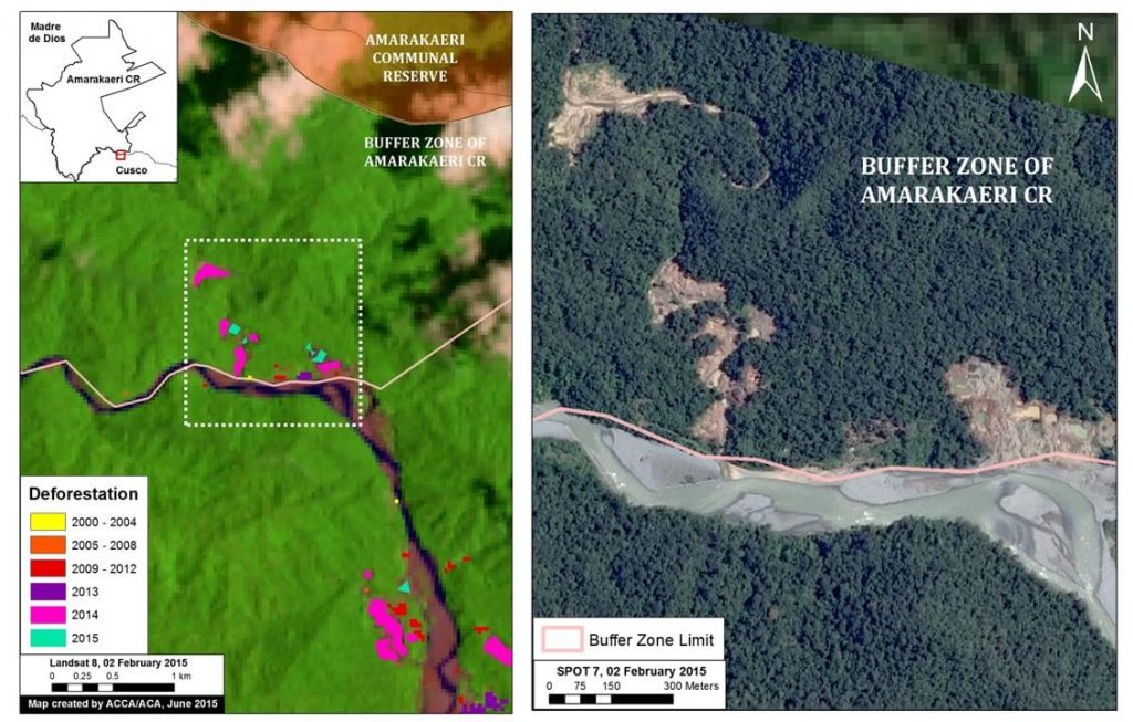
Image 6d. Zoom view of the deforestation within the south-eastern buffer zone of the Amarakaeri Communal Reserve. Left panel shows deforestation results data and right panel shows high resolution SPOT 7 imagery for the area in white dashed lines. Key data sources: MINAM, SERNANP, ACCA, Hansen/UMD/Google/USGS/NASA, USGS, and SPOT 7 from Airbus.

Image 6d shows how gold mining deforestation is encroaching on another part of the south-eastern section of the reserve (see Zoom Area #2 in Image 6a for context). As seen in the left panel, the deforestation within the buffer zone began expanding most notably in 2014 and 2015.

To confirm the driver of the deforestation, we acquired high resolution satellite imagery (SPOT 7 with 1.5 m resolution). As seen in the right panel of Image 6d, the pattern of the recent deforestation is characteristic of gold mining, and not other possible drivers such as agriculture.


Data Description:

Background map is a mosaic of two Landsat 8 images (30 m resolution) from April 10, 2014 and August 30, 2013. Any variation of green indicates forest cover. Note there is some scattered cloud cover. Data is from USGS.

Protected areas data is from SERNANP. Dark green indicates an established Peruvian national protected area or conservation concession and yellow-green indicates an official protected area buffer zone.

Black indicates areas that were deforested as of 2000 according to data from the Peruvian Environment Ministry (MINAM 2009). Yellow, orange, and red indicate areas that were deforested from 2000 to 2012 (each color covers a four year period) (Hansen MC et al. 2013 Science 342: 850–53; Data download).

Purple, pink, and teal indicate areas that were deforested between January 2013 and February 2015 based on our analysis of Landsat imagery using CLASlite forest monitoring software.


Citation

Finer M, Novoa S (2015) Gold Mining Deforestation Enters Amarakaeri Communal Reserve (Madre de Dios, Peru). MAAP: Image #6. Link: https://maaproject.org/2015/08/image-of-the-week-6-gold-mining-deforestation-enters-amarakaeri-communal-reserve/

Image #5: Gold Mining Deforestation Intensifies Along Upper Malinowski (Madre De Dios, Peru)

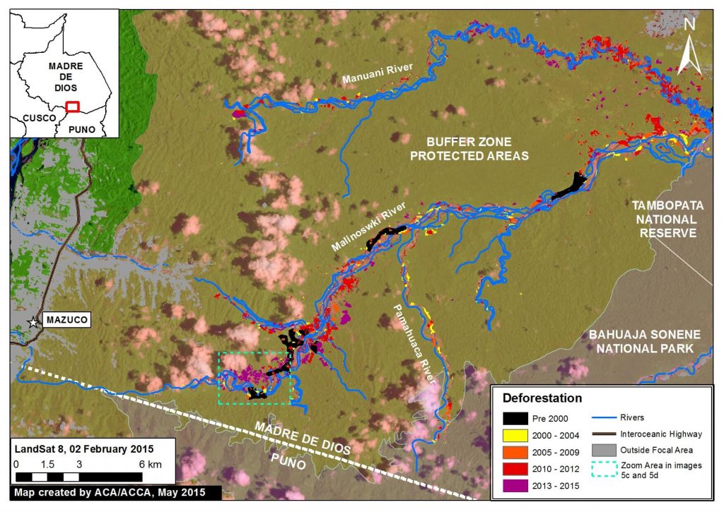
Recall that in Image of the Week #1 we documented how gold mining deforestation continues to expand within the Department of Madre de Dios (Peru) in an area known as La Pampa (1,700 hectares of new deforestation between 2013 and 2015). Here, Image of the Week #5 examines the area immediately to the west of La Pampa along the Upper Malinowski River, where we document over 850 hectares of additional gold mining deforestation between 2013 and 2015. Like La Pampa, most mining along the Upper Malinowski is illegal because it is outside the permissible mining zone and within the official buffer zone of a protected area.

Image of the Week 5a. Expanding deforestation from illegal gold mining along the Upper Malinowski River. Key data sources: MINAM, SERNANP, ACCA, USGS, IBC, Hansen/UMD/Google/USGS/NASA.

Key Results

According to our CLASlite analysis, 864 hectares were deforested between 2013 and 2015 along the Upper Malinowski and nearby tributaries within the buffer zones of the Bahuaja Sonene and Tambopata protected areas.

Image of the Week Description

Background map is a Landsat 8 image (30 m resolution) from February 2, 2015. Any variation of green indicates forest cover. Note there is some scattered cloud cover. Data is from USGS.

Protected areas data is from SERNANP. Dark green indicates established national protected areas and yellow-green indicates their buffer zones.

Black indicates areas that were deforested as of 2000 according to data from the Peruvian Environment Ministry (MINAM 2009). Yellow, orange, and red indicate areas that were deforested from 2000 to 2012 (each color covers a four year period) (Hansen MC et al. 2013 Science 342: 850–53; Data download).

Purple indicates areas that were deforested between January 2013 and February 2015 based on our analysis of Landsat imagery using CLASlite forest monitoring software.

Madre de Dios Mining Zone

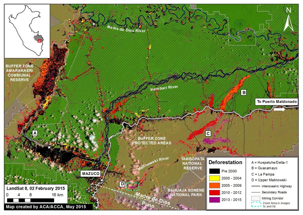
Image 5b. Madre de Dios mining zone, highlighting location of La Pampa and Upper Malinowski. Note that we did not include other land uses such as forestry concessions. Key data sources: MINAM, SERNANP, ACCA, Hansen/UMD/Google/USGS/NASA, USGS.

Image 5b provides greater context of the Madre de Dios mining zone, highlighting La Pampa at “C” (Image of the Week #1) and the Upper Malinowski at “D”.

The Permissible Mining Zone was established in 2010 and indicates the zone that the Peruvian Government has delimited as potentially legal for small-scale and artisanal mining activities, but only if miners succesfully complete a multi-step formalization process for each project. One of the key steps of this process is to resolve any land use conflicts due to overlapping land claims (for example if a section of the mining corridor overlaps with a forestry concession). Data is from ACCA.

Importantly, note that most gold mining in both La Pampa and the Upper Malinowski is illegal since it is located outside the permissible mining zone and within the buffer zone of two protected areas (Bahuaja Sonene National Park and Tambopata National Reserve).

Also note that on the lower Malinowski, deforestation is concentrated on the buffer zone side and largely absent on the protected area side. This striking pattern indicates that official protection status is much more of an effective deforestation deterrent than the looser buffer zone status.

High-resolution Zoom

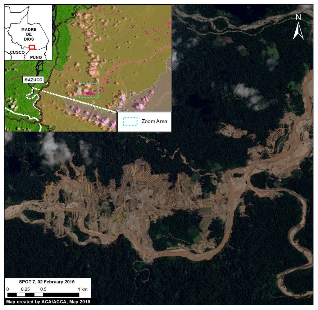
Image 5c. High resolution satellite image of deforestation along the Upper Malinowski River. Key data sources: SPOT 7, CLASlite.

To better understand the driver of the deforestation along the Upper Malinowski, we acquired high resolution satellite imagery (SPOT 7 with 1.5 m resolution). As seen in Image 5c, the pattern of the recent deforestation is characteristic of gold mining, and not other possible drivers such as agriculture. Note that the purple outlines indicate areas that were deforested between January 2013 and February 2015 based on our CLASlite analysis (this image shows 492 of the total 864 hectares of recent deforestation).

Satellite Image Time-series

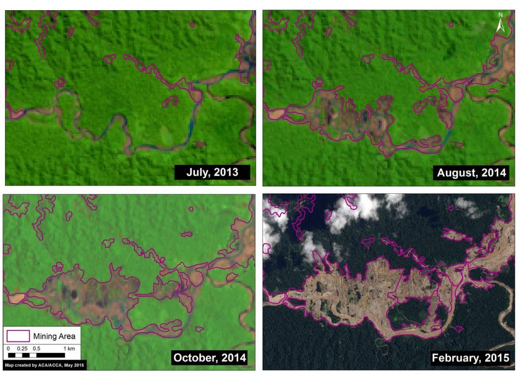
Image 5d. Satellite image time-series (2013 – 2015) of deforestation along the Upper Malinowski. Note that all four panels in Image 5d show the same location. Key data sources: USGS, SPOT 7.

To better understand the deforestation dynamics over time along the Upper Malinowski, we created a satellite image (Landsat and SPOT 7) time-series. As seen in Image 5d, there was a rapid increase in mining deforestation in the less than two years between July 2013 and February 2015. Note that all four panels in Image 5d show the same location, but appear different because of the deforestation.


Citation

Finer M, Novoa S (2015) Gold Mining Deforestation Intensifies along Upper Malinowski (Madre de Dios, Peru). MAAP: Image #5. Link: https://maaproject.org/2015/05/image-5-gold-mining-deforestation-intensifies-along-upper-malinowski-madre-de-dios-peru/

Image #4: Large-Scale Oil Palm Causes Deforestation of Primary Forest in The Peruvian Amazon (Part 1: Nueva Requena)

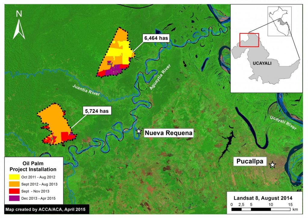
Image of the Week #4 shows the expansion of two large-scale oil palm projects near the town of Nueva Requena in the central Peruvian Amazon (Department of Ucayali). These projects began in late 2011 and, as of April 2015, now cover nearly 12,200 hectares (ha). Our analysis reveals that, of this total area, 9,400 ha came at the expense of primary forest and 2,350 ha from secondary forest.

Image of the Week 4a. Two large-scale oil palm projects near Nueva Requena in the central Peruvian Amazon (Department of Ucayali) began in late 2011 and now cover nearly 12,200 ha. Key data sources: USGS.

Map Description

Background map is a Landsat 8 satellite image (30 meter resolution) from August 2014. Dark green indicates forest cover. Light green indicates younger or secondary vegetation. Blue indicates water bodies. Data is from USGS.

The dashed black lines indicate the outline of the two large-scale oil palm projects, one of which is known to be “Plantaciones de Ucayali”, as of April 2015.

The colors indicate how the deforestation and plantation installation unfolded over time for the two projects according to our analysis of Landsat imagery.

Between October 2011 and August 2012, large scale-clearing and installation (indicated in yellow) started in the northern project.

Between September 2012 and August 2013, large-scale clearing and installation (indicated in orange) continued in the northern project and began in the southern project.

Between September and November 2013, clearing and installation (indicated in red) continued in the southern portion of both projects.

Most recently, between December 2013 and April 2015, clearing and installation (indicated in purple) continued in the southern portion of the northern project.

As of April 2015, the two projects cover an area of 12,188 ha.

Landsat Time-series 2010 – 2015

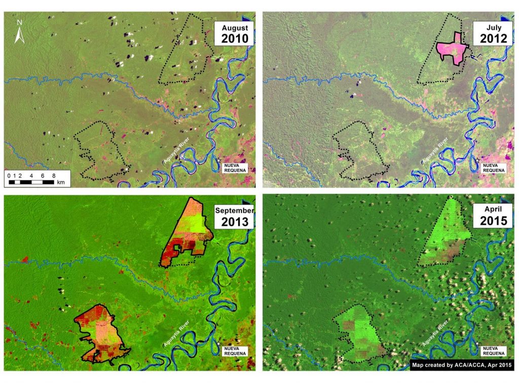
Image 4b. Landsat time-series (2010 – 2015) for both large-scale oil palm projects near Nueva Requena. Key data sources: USGS.

Image 4b is a series of Landsat images showing the change over time for both oil palm projects. In these images, dark green indicates forest cover, light green indicates secondary vegetation and oil palm plantations, pink indicates exposed ground (and is therefore a key indicator of recent deforestation), and the scattered white and black spots indicate clouds and their shade.

The first image, Landsat 5 from August 2010, shows the eventual project area (indicated by dashed black lines) immediately prior to the start of the project in 2011.

The second image, Landsat 7 from July 2012, shows the start of large-scale clearing in the northern portion of the project area.

The third image, Landsat 8 from September 2013, shows the clearing quickly expanded in both projects. It also shows the start of the oil palm plantation planting in the northern project (indicated by bright green).

The fourth image, Landsat 8 from April 2015, is the latest cloud-free image for the project area. It shows the continued expansion of the northern project and the extensive oil palm plantation plantings in both projects.

Landsat Time-series 1990 – 2015

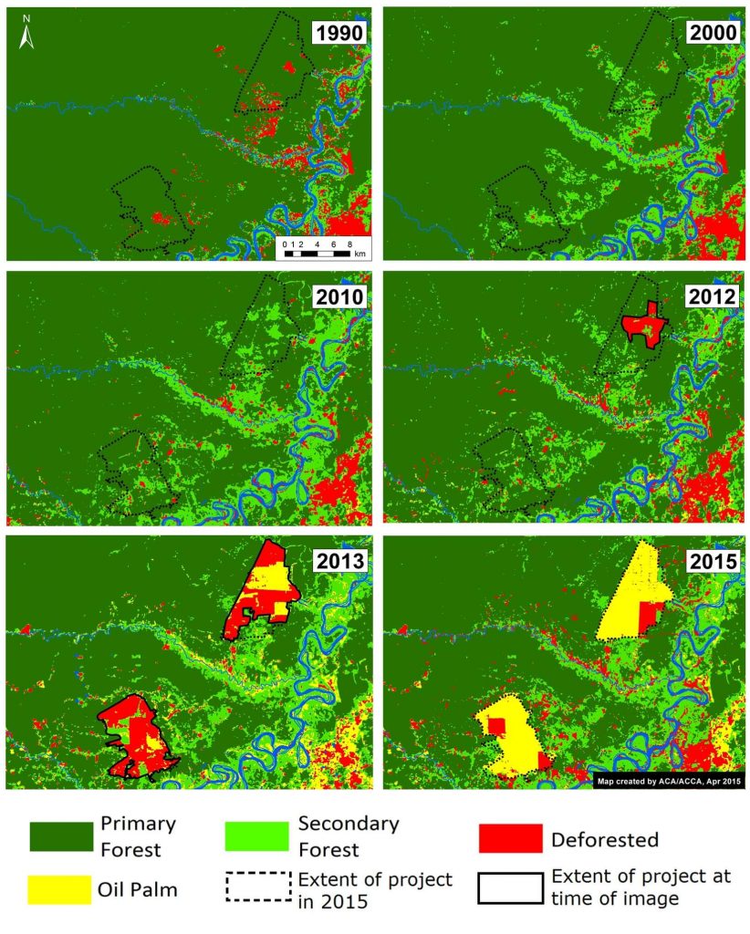
Image 4c. Landsat time-series (1990 – 2015) for both large-scale oil palm projects near Nueva Requena. Key data sources: USGS.

We conducted another Landsat time-series analysis, but going back further in time (to 1990) in order to better understand the state of the forests cleared for the oil palm project. For each image, we determined whether an area was primary forest, secondary forest, deforested, or oil palm. Image 4c illustrates the results of this analysis.

It is important to note that in 2010, just prior to the large scale clearing, the two project areas were mostly a mix of primary and secondary forest.

Deforestation of Primary Forest

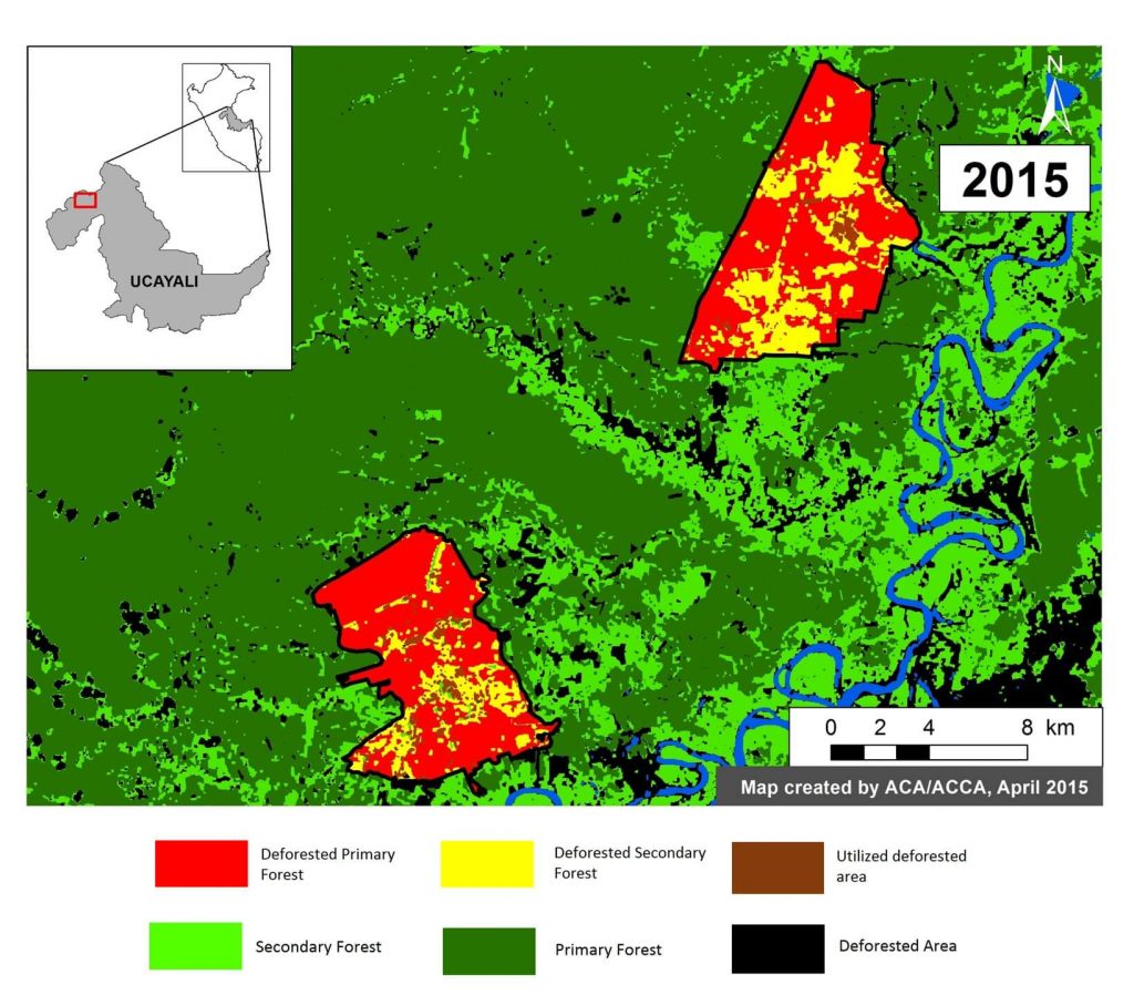
Image 4d. Classification of land use prior to oil palm activities. Key data sources: USGS.

Finally, we used the results from the Landsat time-series analysis to conduct a classification of land use prior to oil palm activities.

We determined that, of the 12,188 ha of the two oil palm projects, 9,404 ha (77%) was primary forest immediately prior to project installation. That is the equivalent to nearly 7,000 soccer fields. An additional 2,350 ha (19 %) was secondary forest. Only 434 ha (4 %) was already deforested at the start of the project.

We defined primary forest as an area that from the earliest available Landsat, in this case 1990, was characterized by dense closed canopy forest cover.

This work builds off of the following publication: Environmental Investigation Agency. Deforestation by Definition. 2015. Washington, DC. http://eia-global.org/news-media/deforestation-by-definition


Citation

Finer M, Novoa S (2015) Large-Scale Oil Palm Causes Deforestation of Primary Forest in the Peruvian Amazon (Part 1: Nueva Requena). MAAP: Image #4. Link: https://maaproject.org/2015/04/image-4-oil-palm-projects-cause-deforestation-of-primary-forest-in-the-peruvian-amazon-part-1-nueva-requena/

Image #3: Detection of New (Logging?) Roads in The Peruvian Amazon

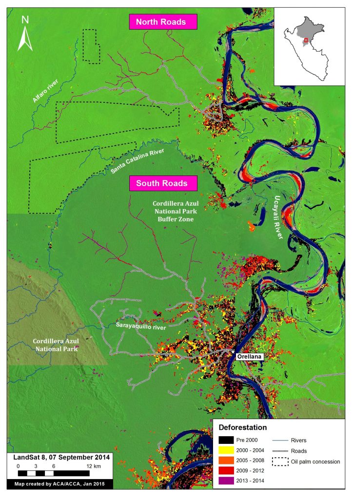
Image of the Week #3 shows the rapid proliferation of two new road networks in the northern Peruvian Amazon (Department of Loreto). Most notably, it highlights the construction of nearly 150 km of new roads, possibly illegal logging roads, through mostly primary forest between 2013 and 2014. One of the roads is within the buffer zone of the Cordillera Azul National Park.

Image of the Week 3. Detection of new road construction in the northern Peruvian Amazon (Department of Loreto) Key data sources: MINAM, Hansen/UMD/Google/USGS/NASA, USGS, SERNANP, Grupo Palmas, GOREL.

Map Description

Background map is a Landsat 8 image (30 m resolution) from September 7, 2014. Green indicates forest cover. Our analysis has demonstrated that much of this forest cover is primary forest. Data is from USGS.

Black indicates areas that were deforested as of 2000 according to data from the Peruvian Environment Ministry. Yellow, orange, and red indicate areas that were deforested from 2000 to 2012 (each color covers a four year period) (Hansen MC et al. 2013 Science 342: 850–53; Data download).

Purple indicates areas that were deforested between 2013 and 2014 based on our analysis of Landsat imagery using CLASlite forest monitoring software. Note the two new road networks, labeled North and South, respectively, to the west of the Ucayali River.

Black dashed lines indicate planned oil palm plantations. We obtained this data from Environmental Impact Studies and the Regional Government of Loreto (GOREL).

Protected areas data is from SERNANP. Note the different shades of green to differentiate the protected area and its respective buffer zone.

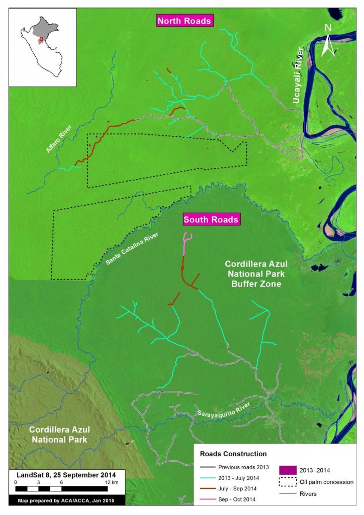
Image 3b. Road construction time-series. Key data sources: USGS, SERNANP, Grupo Palmas.

Construction of New Roads

We color coded the segments of road by construction period: Grey indicates road segments constructed between 2009 and 2012. Teal indicates road segments constructed between January 2013 and July 2014 (117.3 km). Dark-orange indicates road segments constructed between July and September 2014 (25.9 km). Pink indicates road segments constructed between September and October 2014 (4.8 km).

In sum, 148 km of new roads was constructed in this area between January 2013 and October 2014 (76.24 km in south and 77.38 km in the north).

The southern network is characteristic of a logging road in that it does not have a clear destination and instead just keeps extending and branching deeper into closed-canopy forest.

The northern network is more puzzling in that it crosses a proposed palm oil concession (Grupo Romero’s Tierra Blanca project) and terminates at the Alfaro River. Also note several areas of recent deforestation near the road in the northwest corner of the oil palm concession.

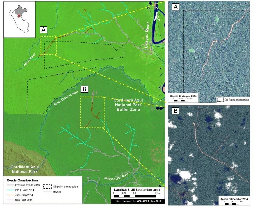
Image 3c. High resolution SPOT 6 images (1.5 m resolution) of portions of the northern and southern road networks. Key data sources: USGS, SPOT 6.

High-resolution zooms

Panel A is a high resolution SPOT 6 image (1.5 m resolution) from August 2014 of a portion of the northern road network.

Panel B is a high resolution SPOT 6 image (1.5 m resolution) from October 2014 of a portion of the southern road network.


Citation

Finer M, Novoa S (2015) Detection of New (Logging?) Roads in the Peruvian Amazon. MAAP: Image #3. Link: https://maaproject.org/2015/04/detection-of-new-road-construction-in-southern-loreto-peru/

MAAP #2: Large-Scale Forest Clearing for Cacao in Tamshiyacu, Peru

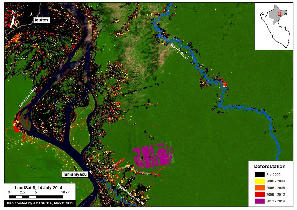
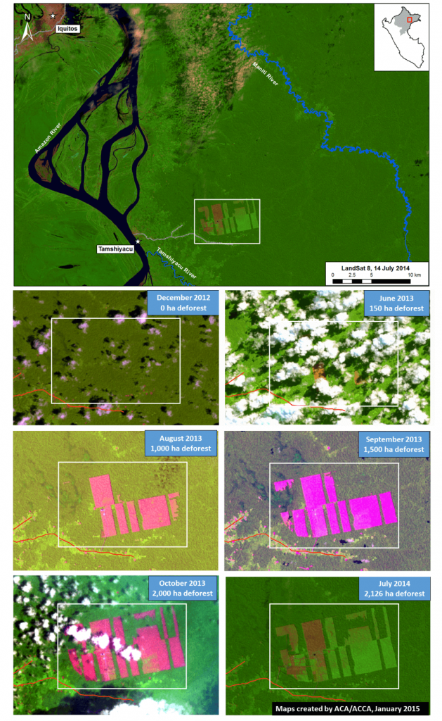
Image of the Week #2 shows the recent and rapid forest clearing for a new cacao project outside of the town of Tamshiyacu in the northern Peruvian Amazon (Department of Loreto). Specifically, we found that over 2,100 hectares (ha) were cleared between May 2013 and August 2014 in an area known as Fundo Tamshiyacu.

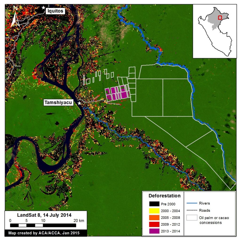
Image of the Week 2a. Rapid clearing for large-scale agriculture in Tamshiyacu (Loreto, Peru). Key data sources: MINAM, Hansen/UMD/Google/USGS/NASA, USGS.


Map Description

Background map is a Landsat 8 image (30 m resolution) from July 14, 2014. Green indicates forest cover. Note there is some cloud cover. Data is from USGS.

Black indicates areas that were cleared as of 2000 according to data from the Peruvian Environment Ministry (MINAM 2009). Yellow, orange, and red indicate areas that were cleared from 2000 to 2012 (each color covers a four year period) (Hansen MC et al. 2013 Science 342: 850–53; Data download).

Purple indicates areas that were cleared in 2013 and 2014 based on our analysis of Landsat imagery using CLASlite forest monitoring software. Using CLASlite, we found that 2,126 ha were cleared between May 2013 and August 2014 in the cacao project area known as Fundo Tamshiyacu. That is the equivalent to 2,900 soccer fields.

See this article published on mongabay.com for more information on the company that carried out the forest clearing (United Cacao, through its subsidiary in Peru, Cacao del Peru Norte). See this article, also published on mongabay, for more information on the legality of the forest clearing.

Landsat Time-series


Image 2b. Results of Landsat time series analysis, December 2012 – August 2014. Key sources: USGS.

Image 2b is a series of Landsat images (30 meter resolution) of the recently cleared area that illustrates how the forest clearing unfolded.

In December 2012, the area was predominantly covered by closed-canopy forest.

In June 2013, although the image is cloudy, we detected the first signs of major forest clearing (about 150 ha).

In August 2013, a cloud-free image clearly revealed that forest clearing jumped to 1,000 ha.

Subsequent images in September and October 2013 revealed that forest clearing continued to 1,500 ha and 2,000 ha, respectively.

During the peak clearing between June and September 2013, the clearing rate was approximately 100 ha per week.

The forest clearing halted between November 2013 and June 2014, but in July 2014 we detected some new clearing. This additional clearing in 2014 raised the total cleared area to 2,126 ha.

Cutting Primary Forest


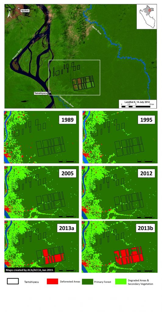
Image 2c. Tamshiyacu Landsat time series, 1989 – 2013. See text for definition of primary forest. Key sources: USGS.

Image 2c shows the results of our analysis of another series of Landsat images of the recently cleared area that go further back in time, until 1985. We conducted this analysis to determine whether the clearing described above came at the expense of primary forest.

We defined primary forest as an area that from the earliest available Landsat (in this case an image from 1985) was characterized by dense closed canopy coverage and having a similar spectral signature (NDVI) as areas in remote areas of the Amazon known to be undisturbed.

Using this methodology, we found that nearly 98% of the recently cleared area in Tamshiyacu was primary forest at the start clearing around May 2013.

Much More Forest Clearing to Come?

Image 2d. Rapid clearing for large-scale agriculture in Tamshiyacu (Loreto, Peru). Key sources: MINAM, Hansen/UMD/Google/USGS/NASA, GOREL, USGS.

Image 2d includes spatial information on proposed cacao and oil palm projects in the Tamshiyacu area (indicated by grey lines). This data was obtained from the Regional Government of Loreto (GOREL). The total area for proposed cacao and oil palm projects around Tamshiyacu is greater than 50,000 ha.

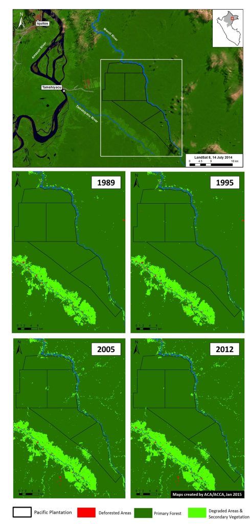
Image 2e. Landsat time series (1989 – 2012) for Pacific Plantation. See text for definition of primary forest. Key sources: USGS, GOREL.

We conducted a Landsat time-series analysis for the proposed oil palm projects noted above. We refer to these proposed projects as Pacific Plantation because this is how they are labelled in the information obtained from GOREL. As seen in Image 2e, our analysis indicates that 99.3% of the Pacific Plantation project area, or 44,685 ha, is primary forest.


Citation

Finer M, Novoa S (2015) Large-scale Forest Clearing for Cacao and Oil Palm in Tamshiyacu, Peru. MAAP: Image #2. Link: https://maaproject.org/2015/03/image-3-rapid-clearing-for-large-scale-agriculture-in-tamshiyacu-_/


Image #1: Gold Mining Deforestation Continues To Expand In La Pampa (Madre De Dios, Peru)

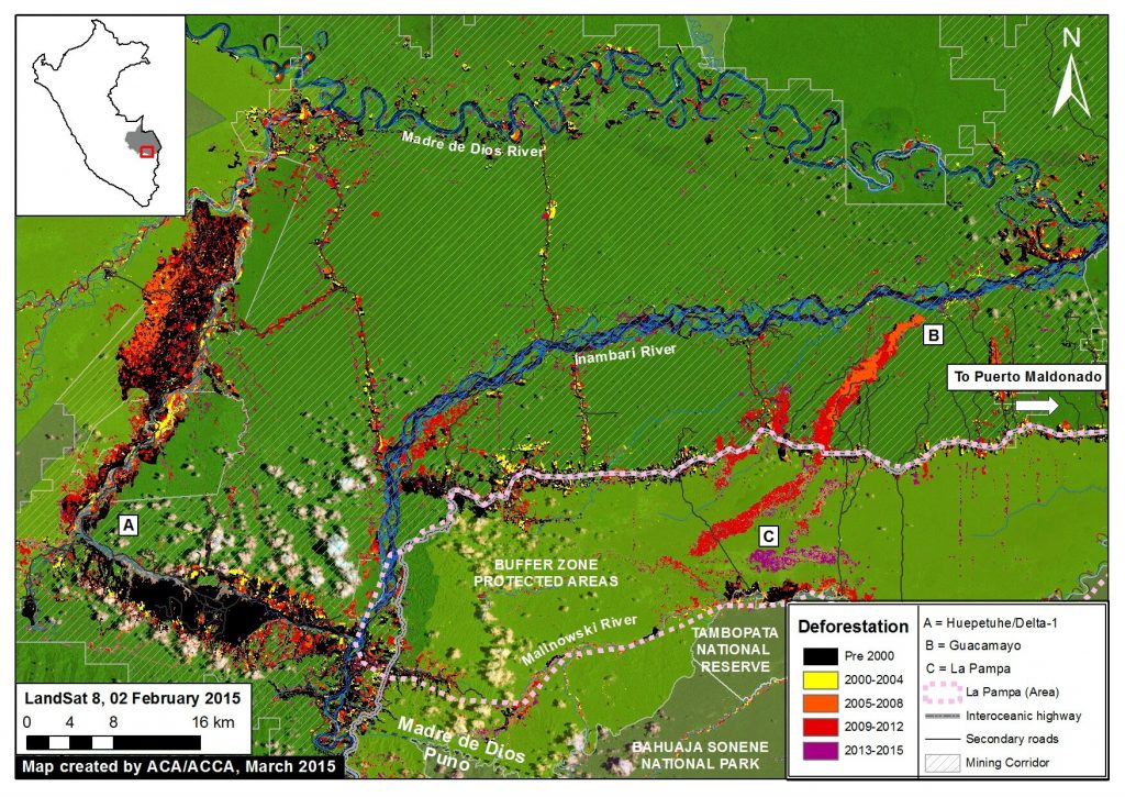
Image of the Week #1 highlights that gold mining deforestation continues to expand in the southern Peruvian Amazon (Department of Madre de Dios). Most notably, the image illustrates that much of the most recent (2013 – 2015) deforestation occured a) in an area known as La Pampa, b) outside of the legal mining corridor, and c) within the buffer zone of the Tambopata National Reserve.


Image of the Week 1a. Deforestation in the mining corridor of Madre de Dios in the southern Peruvian Amazon from 2000 – 2015. Key data sources: MINAM, SERNANP, ACCA, Hansen/UMD/Google/USGS/NASA, USGS


Map Description:

Background map is a Landsat 8 image (30 m resolution) from February 2, 2015. Green indicates forest cover. Note there is some cloud cover. Data is from USGS.

Black indicates areas that were deforested as of 2000 according to data from the Peruvian Environment Ministry (MINAM 2009). Yellow, orange, and red indicate areas that were deforested from 2000 to 2012 (each color covers a four year period) (Hansen MC et al. 2013 Science 342: 850–53; Data download).

Purple indicates areas that were deforested between January 2013 and February 2015 based on our analysis of Landsat imagery using CLASlite forest monitoring software.

Data for secondary roads is from Conservación Amazónica-ACCA.

The mining corridor indicates the zone that the Peruvian Government has delimited as potentially legal for mining activities, but only if miners successfully complete a multi-step formalization process for each project. Data is from ACCA.

Protected areas data is from SERNANP. Dark green indicates established protected areas and light green indicates their buffer zones.

The majority of the forest loss shown on the map is associated with gold mining activity, although some is also associated with the recently paved Interoceanic Highway and its growing secondary roads network.

According to a recent study published in PNAS by Greg Asner et al., the gold mining deforestation in this region increased from 10,000 ha in 2000 to 50,000 hectares (ha) in 2012. This deforestation was concentrated in two primary areas: Huepetuhe/Delta-1 and Guacamayo (A and B on the map, respectively).

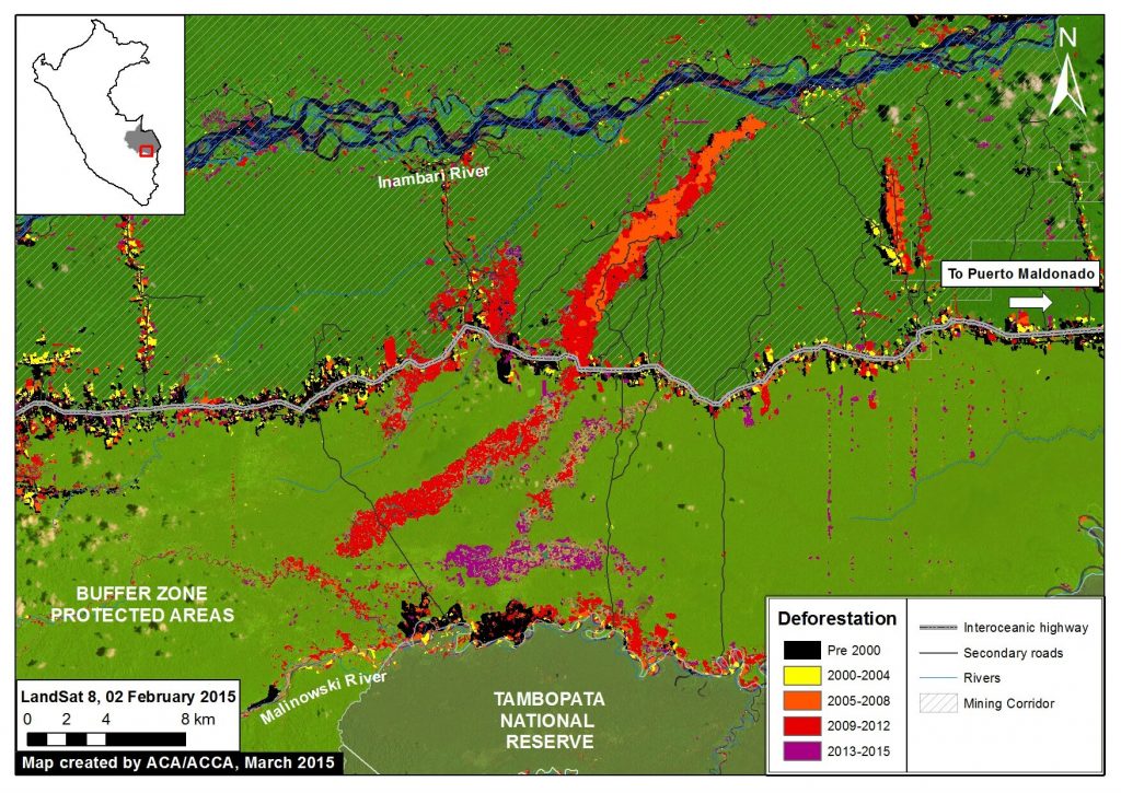
More recently, the deforestation has largely shifted to La Pampa (C on the map). This shift is particularly important because La Pampa is within the buffer zone of the Tambopata National Reserve and outside of the designated mining corridor. Using CLASlite, we detected 1,711 ha of deforestation in La Pampa between 2013 and 2015.


Zoom View of La Pampa

Image 1b. Zoom view of La Pampa mining zone within the buffer zone of the Tambopata National Reserve. Key data sources: MINAM, SERNANP, Hansen/UMD/Google/USGS/NASA, ACCA, USGS

Image 2b is a zoom view of the La Pampa area provided to better illustrate the most recent deforestation within the Tambopata National Reserve buffer zone. As noted above, using CLASlite we detected 1,711 ha of deforestation within the La Pampa area between 2013 and 2015. That is the equivalent to more than 2,300 soccer fields.

Note that much of the most recent deforestation is within 6 km of the Tambopata National Reserve.


Near Real-time Monitoring

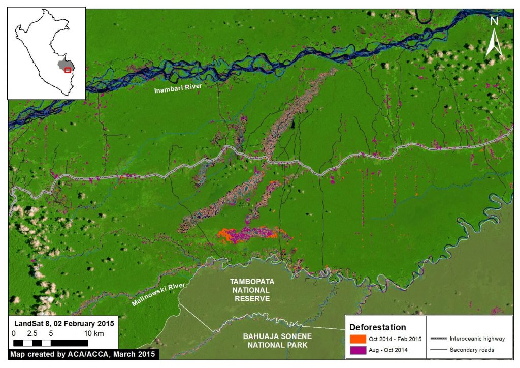
Image 1c. Near real-time deforestation monitoring in La Pampa. Key data sources: SERNANP, USGS, ACCA

Thanks to a series of relatively cloud-free Landsat images, we were able to conduct near real-time analysis with CLASlite during 2014 and 2015.

For example, we found that between mid-October 2014 and early February 2015 (about four months) there was deforestation of 226.5 ha in La Pampa within the buffer zone of the Tambopata National Reserve. That is the equivalent to 310 soccer fields, a rate of over 2.5 fields a day.

Prior to that time period, we found that between mid-August and mid-October 2014 (abount nine weeks), there was deforestation of 431 ha in La Pampa.


Citation

Finer M, Novoa S (2015) Gold Mining Deforestation Continues to Expand in La Pampa (Madre de Dios, Peru). MAAP: Image #1. Link: https://maaproject.org/2015/03/gold-mining-deforestation-expand-peruvian-amazon/