MAAP #80: Amazon Beauty, in High-Resolution

MAAP tracks the most urgent deforestation cases in the Andean Amazon, thus it can be a bit depressing. However, it is important to remember why we do it: the Amazon is spectacular.

Image 80. Base Map. Data: SERNANP, MAAP

Here, we present a series of high-resolution satellite images to show the incredible beauty of the Peruvian Amazon, and help remind us all why it is so important to protect.

All the images, obtained from DigitalGlobe, are both recent and very high resolution (less than 0.5 meters). Together, they form an art exhibition, starring the forests, rivers, and mountains of the Peruvian Amazon.

The categories of the images are: “Protected Areas” and “Threatened Areas.”

The Protected Areas include National Parks (Yaguas, Sierra del Divisor, and Manu); National Reserve (Tambopata); Communal Reserve (Amarakaeri); and Regional Conservation Area (Choquequirao).

The Threatened Areas include areas at risk due to gold mining, road construction, hydroelectric dams, and new oil palm and cacao plantations.

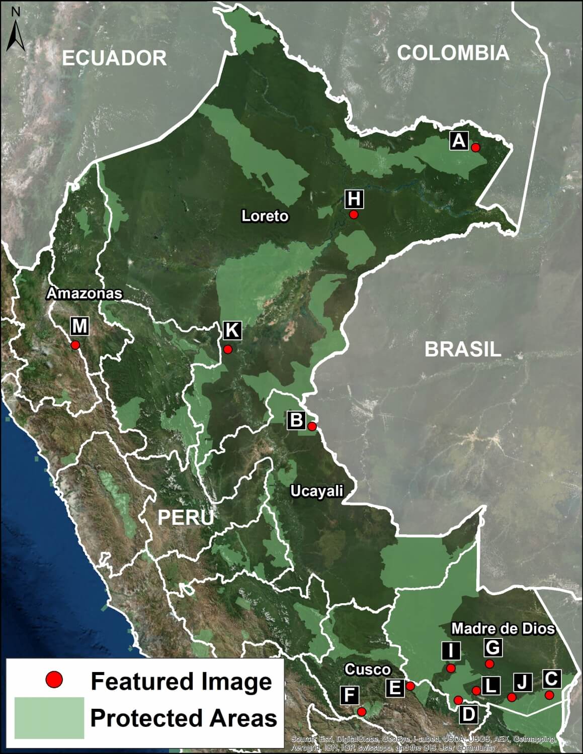
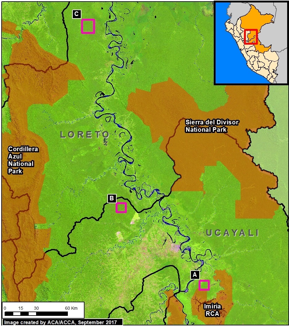
Click on each image to enlarge. See the base map for the location of each image (A-M).

MAAP #79: Seeing Through the Clouds: Monitoring Deforestation With Radar

MAAP has repeatedly emphasized the power and importance of Earth observation satellites with optical sensors (such as Landsat, Planet, DigitalGlobe).

Imagen 79. Satélite de radar, Sentinel-1. Creado por MAAP

However, they also have a key limitation: clouds block the data about Earth from reaching the sensor, a common problem in rainy regions like the Amazon.

Fortunately, there is another powerful tool with a unique capability: satellites with radar sensors, which emit their own energy that can pass through the clouds (see Image).

Since 2014, the European Space Agency has provided free imagery from its radar satellites, known as Sentinel-1.

In the Peruvian Amazon, for example, Sentinel-1 obtains imagery every 12 days with a resolution of ~20 meters.

Here, we show the power of radar imagery in terms of near real-time deforestation monitoring. We focus on an area with ongoing deforestation due to gold mining in the southern Peruvian Amazon (Madre de Dios region).

MAAP #78: Deforestation Hotspots in The Peruvian Amazon, 2017

As we begin a new year, we make an initial assessment of 2017, estimating deforestation hotspots in the Peruvian Amazon based on early warning alert data.*

Base Map (Image 78). Data: PNCB/MINAM, UMD/GLAD, SERNANP

We estimate the annual forest loss of 354,410 acres (143,425 hectares) across Peru in 2017. If confirmed, this total represents the lowest in 5 years (average of 394,600 acres since 2012), and a decrease of 13% from last year.**

Deforestation, however, is still widespread. The base map shows the most intense hotspots (areas with highest density of forest loss).

The two main deforestation areas are clearly seen: the central Amazon (Ucayali/Huánuco regions) and the southern Amazon (Madre de Dios). Also, there are several additional hotspots scattered throughout the country.

We present satellite images (slider format) of the most intense hotspots. The images reveal that the main deforestation drivers include gold mining, oil palm, and general agriculture (crops and livestock).

The hotspots detailed below are:

A. Central Amazon (Ucayali/Huánuco)
B. Southern Madre de Dios
C. Iberia (Madre de Dios)
D. Northeast San Martín
E. Nieva (Amazonas)

MAAP #76: Proposed Road Would Cross Primary Forest Along Peru-Brazil Border

In December 2017, the Peruvian Congress approved a bill that declared it in the national interest to construct new roads in the border zone of Ucayali region, which shares a remote border with Brazil.

Image 76a. Base Map. Data: Mosaic of 16 images from Sentinel-2/ESA, July 2017

The main proposed road in this border area would cover 172 miles and connect the towns of Puerto Esperanza and Iñapari, in the Ucayali and Madre de Dios regions, respectively. Image 76a, a mosaic of satellite images from July 2017, illustrates just how remote and intact is the area surrounding the proposed road route.

Indigenous organizations and the Ministry of Culture have warned that the road would have major impacts on the indigenous peoples in voluntary isolation that are documented to inhabit parts of this remote area.

In this report, we add new information that complements the evaluation of possible impacts by calculating how much primary forest would be threatened as a result of road construction. We found that around 680,000 acres (275,00 hectares) of primary forest are at risk. Much of this area is within protected areas and a reserve for isolated indigenous groups.

MAAP #75: Pope to Visit Madre De Dios, Region With Deforestation Crisis (Peru)

Table 75. Data: PNBC/MINAM (2001-16), UMD/GLAD (2017, until the first week of November).

Pope Francis, as part of his upcoming visit to Peru in January, will visit the Madre de Dios region in the southern Peruvian Amazon. He is expected to address issues facing the Amazon and its indigenous communities, including deforestation.

In this article, we show that Madre de Dios is experiencing a deforestation crisis, due mainly to impacts from gold mining, small-scale agriculture, and roads.

Table 76 shows the increasing trend of annual forest loss since 2001, peaking in 2017. In fact, in 2017 forest loss exceeded 20,000 hectares (49,000 acres) for the first time, doubling the loss in 2008.*

The table also shows the ranking of Madre de Dios in respect to the annual forest loss compared to all other regions of the Peruvian Amazon (see red line). For the first time, Madre de Dios is the region with the second highest forest loss total, behind only Ucayali.

Next, we present a map of deforestation hotspots in Madre de Dios in 2017, along with satellite images of a number of the most intense hotspots.

*The total estimated forest loss in 2017 was based on early warnings alerts generated by the University of Maryland (GLAD alerts) and the Peruvian Environment Ministry (PNCB/MINAM). The estimate is 20,826 hectares as of the first week of November.

MAAP Interactive: Deforestation Drivers In The Andean Amazon

Since its launch in April 2015, MAAP has published over 70 reports related to deforestation (and natural forest loss) in the Andean Amazon. We have thus far focused on Peru, with several reports in Colombia and Brazil as well.

These reports are meant to be case studies of the most important and urgent deforestation events. We often use forest loss alerts (known as GLAD) to guide us, and satellite imagery (from Planet and DigitalGlobe) to identify the deforestation driver.

Here we present an interactive map highlighting the drivers identified in all published MAAP reports. These drivers include gold mining, agriculture (e.g. oil palm and cacao), cattle pasture, roads, and dams (see icon legend below map). We also include natural causes such as floods and blowdowns (fire included under agriculture since most human caused). Furthermore, we highlight deforestation events within protected areas. Note that you can filter by driver by checking boxes of interest.

We hope the result is one of the most detailed and up-todate resources on patterns and drivers of deforestation in the Andean Amazon. Over the coming year we will continue to focus on Peru and Colombia, and begin to include Ecuador and Bolivia as well.

To view the interactive map, please visit:

MAAP Interactive: Deforestation Drivers in the Andean Amazon
https://maaproject.org/interactive/

For more information on patterns and drivers of deforestation in the Peruvian Amazon, see our latest News and Resources 

MAAP #74: Landslides in The Peruvian Amazon

Image 74. Base Map. Data: SERNANP

In addition to the human-caused deforestation emphasized in MAAP, there is also natural Amazonian forest loss. The causes include meandering rivers, wind storms (see MAAP #70), and the subject of this report: landslides.

Amazon landslides may be caused by heavy rains in rugged areas. Many landslides occur in protected areas, which often include steep and unstable areas.

Here, we show satellite images of 3 recent examples of large landslides in protected areas in the Peruvian Amazon. We document the natural forest loss of 685 acres (280 hectares) in these examples, indicating that landslides are an important natural phenomenon in the Amazon.

Example A: Sierra del Divisor National Park
Example B: Cordillera Azul National Park
Example C: Bahuaja Sonene National Park

MAAP #72: New Gold Mining Deforestation Zone in Peruvian Amazon: The Upper Malinowski (Madre De Dios)

In a series of previous reports (MAAP # 60), we have described the dire gold mining deforestation in the southern Peruvian Amazon, most notably in the area known as “La Pampa” (see Base Map). However, over the past 3 years another critical area has emerged in the region: the Upper Malinowski. This area is located near the headwaters of the Malinowski River, upstream of La Pampa (see Base Map).

Here, we show satellite images of the rapid advance of gold mining deforestation in two sectors of the upper Malinowski. In total, we document the deforestation of 3,880 acres (1,570 hectares) between 2015 and 2017 inside the buffer zone of the Bahuaja Sonene National Park.

Mapa Base. Datos: SERNANP, UMD/GLAD, MINAM/PNCB, Hansen/UMD/Google/USGS/NASA

MAAP #70: “Hurricane Winds” In the Peruvian Amazon, A 13 Year Analysis

In an earlier report, MAAP #54, we described the natural phenomenon of “hurricane winds” in the Peruvian Amazon. These strong wind storms (not true hurricanes) cause a chain reaction of fallen trees and may blow down hundreds of acres of Amazonian forest (see Drone Image below).

This report presents an analysis of the frequency and intensity of hurricane winds in the Peruvian Amazon over the past 13 years (2005-17). The analysis is based on the annual forest loss data and early warning alerts data.

Drone Image. Source: ACCA

MAAP #69: Alarming Deforestation Patterns in The Central Peruvian Amazon

Image 69. Base Map.
Image 69. Base Map.

Thanks to early warning forest loss alerts (known as GLAD), we recently detected several alarming new deforestation patterns within remote, primary forest of the central Peruvian Amazon.

They appear to be related to medium or large-scale agricultural activities due to their distinct characteristics: straight access paths extending from secondary roads built deep into primary forest, and deforestation of rectangular/square plots.

These patterns are significant because they are very different than the usual patterns observed with small-scale agriculture in the Peruvian Amazon: scattered plots with no major linear features.

Here, we show satellite images of 3 areas in the central Peruvian Amazon (see Base Map) that have recently experienced these alarming patterns, and deserve urgent attention due to the threat of rapid deforestation of large swaths of primary forest.*